
October is my favorite month of year to be a Pacific Northwest boater. I join the fraternity of paddlers from across the region in anxious anticipation for the arrival of the fall rains. This past fall they arrived with overwhelming intensity.
Following a record dry summer with barely an inch of rain, a series of fronts roared across the Pacific drenching Western Washington and British Columbia. Ironically, the rains hit right as my friends Mike & Elise Giddings arrived from North Carolina to go to the famous Skookumchuck Narrows for surfing. A plan is a plan, however, so we dutifully stuck to the one we had made: three days of surfing and camping at Skookumchuck. That is, until we discovered on the first day that the wave never really formed, on the second day we had heavy rains and violent winds, and for the third day there was a small-craft advisory for severe storms. We bailed out on the second day, returning to Seattle, Mike and Elise temporarily disappointed.
Tom and Mike enjoying Skook
The Sultan River could be one of Western Washington’s most popular whitewater resources. With the take-out less than an hour from downtown Seattle, and 13 miles of incredible class III to IV+ whitewater in a stunning bedrock canyon, it was once one of the region’s premiere whitewater rivers. Unfortunately the City of Everett tapped the river for it’s municipal water supply at the beginning of the 20th century. A still functioning small diversion dam was constructed in 1930. A storage reservoir was constructed 6.5 miles upstream of that in 1965 with the construction of Culmback Dam. With limited storage capacity in the original reservoir, high flows continued to create whitewater opportunities until 1982 when the Culmback Dam was enlarged to its current size. The result was to eliminate the spectacular whitewater that had been available on the Sultan. Now flows in the riverbed are limited to a small trickle that weaves its way under and around the boulders.
That’s why paddling opportunities these days on the upper Sultan occur only when the level of Spada Reservoir reaches the overflow tubes and again returns to the channel. The water managers seem to have become increasingly proficient at making sure no water is “wasted” by funneling every possible drop down through the tubes to the powerhouse 11 miles downstream from the dam, and keeping plenty of storage capacity available to absorb the onslaught of winter storms such that overflow typically occurs only once every several years.
There is one exception to this overflow rule: when extremely heavy rains hit Western Washington. Once or, if we’re lucky, a couple times a year a storm can hit that provides sufficient inflow to the bedrock canyon such that the river has boatable flows for a few short hours without any spill from the reservoir. Unfortunately, Seattle area boaters haven’t yet figured out how to control the weather, so this can happen any day of the week. The flows drop instantly as soon as the rain tapers off, so the only remedy is to call in sick with a case of the “Sultan flu” and get to the river. Even then, it’s only with luck that enough flow enters the canyon during daylight hours.
There are additional factors that further complicate the logistics of the run. Given the difficulty of predicting the flood crest you often don’t have a good idea of what flows might be until 11 pm the night before. And even that is contingent upon continuing rain leading up to the run. The upper Sultan flows through a remote river canyon requiring full preparation for an expedition type trip. That means maps, extra food, headlamps and all the other assorted safety gear.
Then there’s the matter of getting to the river itself. Terrorism paranoia has closed the road to the dam, requiring a two mile hike in on the road followed by precise navigation of the mining trails down to the river. The trails aren’t completely obvious and you don’t want to expend a lot of energy in trial-and-error route finding with a heavy boat and all your expedition gear on your shoulder. Once on the water, there are 11 miles of whitewater before the powerhouse, which hopefully can be reached before dark, because it is followed by two miles of swollen river with the addition of 1,200 cfs from the tubes. As a minor bonus, the most difficult rapid on the river lies in this stretch—Last Nasty—which becomes a boater-hungry monster at high water.
The evening of October 20th, 2003, after the aborted Skook trip, the rain was still coming down hard and it was looking like a good opportunity to explore the Sultan River canyon. Mike had been a companion on a few epic adventures we’ve shared over the past decade, and as always was up for a little adventure. He’s also the individual responsible for redirecting my life to that of a whitewater junkie. Elise saw right away that this had all the makings of an epic, so she had the sense to stay in Seattle and drink some good coffee instead. A local friend, Chris Fuller, still enjoys the freedom of a graduate student schedule, and was also ready to join the adventure.
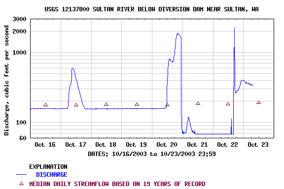
We awoke early the next morning to learn that the rain had tapered off and flows were on their way down. More troubling, when we pulled up the internet gauge, with the station located midway through the upper canyon, flows had apparently dropped instantly from 2000 cfs to 70 cfs at around 11 PM. Convincing ourselves that there was no way the river could just turn off like a lightbulb (the water has to go somewhere, right?), we set out for the river as the sun began to break through the clouds. Besides, the nearby Skykomish River had peaked at a high flood stage of 90,000 cfs and was still cranking.
A puzzling hydrograph
After arranging the shuttle, and a stop for some nourishment, it was approximately 9 AM as we left our cars and began the hike down to the river. Later, we would be told by seasoned Sultan veterans that this should have been more like 7 AM. The hike started out easy, since it was downhill, and we knew right where to go by following the paved road to the dam and then an old logging road that parallels the canyon below it on river left for a couple miles.
Chris and Tom start the hike down the road towards the dam.
We wanted to get far enough downstream from the dam so that the many small streams coming in would provide enough water to the riverbed so that a kayak was minimally floatable. Our bubble was quickly burst: the first obstacle appeared before us when we discovered that several hundred feet of the logging road had recently been lost in a massive landslide. Looking high up the slope we could see the initiation point that had triggered a slurry of mud, boulders and mature trees that had been tossed down the slope like a box of toothpicks. It looked like a wasteland from one of those summer blockbuster calamity films.
Chris at the "end of the road" as he begins the long slog through the debris slide
We later learned this was only one of many road failures that occurred throughout the National Forest on the slopes of the Western Cascades resulting in millions of dollars of road damage. The task before us was to cross the muddy slurry that extended downslope to the river below. Or, we could turn back. We wondered, should we commit further to this adventure? Or should we keep going, facing whatever fate awaited us on the other side? The wondering did not last long. The Sultan called to us, luring us forward. Sinking waist-deep in the water-saturated soil and climbing up, over and through the downed timber, we began what would be a very rough day for our drysuits. More than an hour later we had crossed the landslide and were committed to the Sultan. We then began looking for the well-worn, but somewhat hidden, trails leading down to the river. Gold was first discovered in this river back in 1870 and local prospectors continue to work their claims and maintain informal access routes down to the river. After a few temporary mis-routings, we found a small, steep trail to the river.
It was nearly noon when we finally reached the river, and we had already burned nearly half the available daylight. We all knew that with 13 miles of river before us (none of us had paddled this upper section before), and sunset coming shortly after 6 PM, we had to work efficiently to make it out before dark. We also knew that Last Nasty, the most significant rapid on the run, loomed downstream below the powerhouse near the end of the run.
Tom and Chris finally at the put-in as about 150 cfs trickles past
After a short break to recover energy after our pleasant landslide slog, we were in our boats and on our way down the river. The flow was barely 150 cfs, just enough to bump down. With only a trickle at the base of the dam, the bypass reach is entirely dependent on inflow from the sides. With the steep bedrock walls of the gorge the river has a small effective watershed area and flows were obviously dropping quickly with the break in the weather. We were treated to a beautiful scene, however, as small headwater streams cascaded over the canyon rim, fanning out in an impressive display that provided sustenance for the equally amazing hanging gardens that carpeted the canyon walls with a diverse array of mosses and ferns. The beauty of this temperate rain forest was in full display and the whitewater quickly went from mediocre to good as we continued on downstream with more flow pouring in every few hundred yards.
Chris nails a boof in one of the early rapids
While the early rapids involved technical slalom moves through low water channels, we were able to set a good pace. The constrained nature of the river through the bedrock canyon meant we had good pools with plenty of water to float our boats. We imagined how fun this would be with the full power of a free-flowing river creating what would be some truly wonderful whitewater.
Tom at the base of one of dozens of waterfalls that cascade off the rim into the river
Approaching the old diversion dam at mid-afternoon we were finally paddling with plenty of water. Although the section we had just passed through turned out to be the most scenic of the trip, the rapids waiting downstream would provide the best whitewater. We portaged the diversion dam on the right and a worker from the public utility came over to see what we were up to. He was out checking on the dam and we asked him about the strange behavior of the gauge the night before. He explained that he had come out to flush the gravel by opening a gate on the dam at 11 PM and that a corresponding change in stage height when he did this meant that the gauge was no longer reading in the appropriate range.
Not having time to sit around and shoot the breeze, we got back on the river. We estimated the flows to be about 1,000 cfs and the whitewater had come to life. We were treated to a series of pool-drop rapids, each with fun and challenging lines and most of which could be safely boat scouted.
Although we found the run remarkably clear of wood there were still a number of log hazards. We spent some time scouting one drop in particular that consisted of a series of two holes and a runout that pushed into a series of logs that were wedged vertically on end. I took the lead and after getting knocked off course in the first hole I flailed through the second before bouncing up against the wood on river left, managing to stay upright and paddle away. Chris didn’t fare quite as well—he flipped, and after one or two failed roll attempts, bailed out. His boat gravitated directly for the logs on the side, but luckily he didn’t. Even before this, Mike had come to the conclusion that walking the rapid—and not having to deal with the possibility of a rescue—was the better choice. He quickly leaped into action to try to extract Chris’s boat from the logs and the boiling pot at the base of the drop. As the rescue slowly progressed, there was the constant awareness that we were loosing valuable minutes of daylight, and that making it out before dark was a rapidly receding possibility.
Chris reunited with his boat
We bombed down a series of challenging class IV boulder gardens and ledges as the sun dropped below the canyon walls and a hazy grey mist enveloped the canyon. It was amazing how much the character of the run had changed with dozens of small tributaries that had pumped the flow up to a respectable level. Despite the impending darkness we were having fun.
Marsh Creek Falls explodes into the Sultan from river left in an impressive cascade, just beyond which is the last big rapid of the upper section. We stopped to scout, ever aware of the impending darkness, and could see the river disappear into a hydraulic of unknown proportions. We didn’t have time to adequately scout the rapid in the narrow gorge, so Chris decided to begin a long portage along the right. Not being deterred, I set off downstream with a couple optional routes in my head, and luckily for me plan B got me through the big pour-over on the right hand side. After seeing my results as probe, Mike followed my plan B route, and came through wet but unscathed. Chris launched into the pool below the drop, and we paddled rapidly on downstream.
It was a sprint down to the powerhouse as we worked our way quickly through a long section of class III rapids known to local paddlers as the Horseshoe Bend section. I was now on a stretch of the river I had run before. We finally made it to the powerhouse as dusk approached and the security lights illuminated the landscape with an eerie orange glow.
Below us the river doubled in size as the full force of an additional 1,200 cfs joined the already healthy flow in the constrained bedrock channel. I hadn’t given Chris or Mike much confidence when I told them that Last Nasty, one of the first rapids we’d encountered on the now swollen river, and the biggest one of the day, would likely come up fast and that I might not recognize it since I had never been on this section at these extremely high levels. With apprehension they followed a long distance behind me and I began to question my own judgment as the light levels continued to drop upon entering the dense forest canopy of the lower gorge and I searched for the must-make eddy above Last Nasty.
After a couple time-wasting false alarms, I found the eddy above Last Nasty and although I was tempted by the idea of running it and being done in a few seconds, the light was already dim and it was obvious that we wouldn’t have time to scout it and still have daylight left to run it. We also had to consider that in the diminished light and in our tired condition, a rescue would be very difficult, so we decided to accept our punishment consisting of a tough portage along the right. As we scrambled along a very steep, mud-covered and densely-vegetated bank in the twilight with our boats, the river below us surged through an impressive gauntlet of holes and exploded in a fantastic display of hydraulic power. It was potentially runnable but determining how to negotiate it was a puzzle that would take some planning and our time was up. We continued dragging our boats through the vegetation-choked portage as a blanket of darkness covered the canyon. The portage consumed at least a half hour and the rest of the remaining daylight.
As we put in at the base of Last Nasty I could just barely make out the other side of the river. We had just under 2 miles of whitewater to go before the end of the canyon. It was a section of class III that I knew well—at much lower flows—but with the high water and the light all but completely gone, it was difficult to pick safe lines and as the minutes quickly ticked by the challenge became greater. A swim would have meant certain loss of equipment, and possibly much worse. Boulders and holes would appear out of nowhere to grab our kayaks and do as they pleased with us. Finally, with Chris spending a little more time in a hole than he felt comfortable, and Mike unable to see him at 20 ft. and landing in the same hole, we made our decision to stop. It was now totally dark and although I estimated we were less than half a mile from our goal we had pushed beyond the limits of reasonable safety.
A light rain began to fall as we began the arduous task of climbing out of the canyon to the ridge. We exhaustedly climbed up a steep, fifty-degree mud and vegetation covered slope, several hundred feet in the dark (it seemed like several hundred yards), roping our boats in relay fashion up with us. This is where the value of being prepared for “expedition” conditions payed off: we all had ropes and flashlights, as well as a bit of extra food. Without these we would have unquestionably spent the night in the canyon. We looked forward to getting to the top where our map indicated things would flatten out. Much to our dismay we found ourselves in the middle of a dense blackberry patch. Though we had headlamps, it was one of those nights where the foggy mist just scatters the light in every direction, and combined with the dense thicket, it was only possible to see about 10 feet in each direction, all of which looked the same.
Chris in the middle of the blackberry patch
Smashing blackberry canes as big as healthy saplings by sliding along on our stomachs with boats out in front, we crawled in the direction of what we thought was the nearest road. The blackberry thorns took a toll on my brand-new drysuit—Mike took his drysuit off, and instead his legs and arms took the toll. The evening reached a low point when we discovered that we were actually moving back upstream, having turned ourselves around completely in the blackberry thicket. Eventually we found a trail that led us downriver, and even allowed walking instead of crawling. The trail then joined an old logging road, and we went forward with elation and disbelief that the epic was almost over. From the time we had left the river to hike less than a mile, it had taken us several hours to finally reach the take-out; on the river it would have been 10 (very dangerous) minutes. Andy Bridge, the unofficial steward of the Sultan River, with his house at the take-out, was there to greet us with his wife. This was a welcome homecoming. We refueled our dehydrated and tired bodies before running the long shuttle and finally making it home from what had been a very memorable adventure on the Sultan River. Though each of us was exhausted and sick of blackberry bushes, we all would gladly run the river again (albeit with an earlier start).
Logistics:
Additional information on the run and associated logistics can be found on the Upper Sultan page on the American Whitewater website.
The challenges to running the upper Sultan are considerable, mainly as a result of somewhat complicated logistics. One must be willing to take advantage of a winter rainstorm on a moment’s notice (likely at 11 PM the night before and usually on a weekday), to get expedition gear ready and shuttle set before it’s even light the next morning, to be prepared to hike your boat in at least two miles and possibly longer depending on the snow situation at Olney Pass, and to be willing to negotiate Last Nasty (most likely as dusk approaches) with what may be too much water.
Despite these barriers, the upper Sultan River is still enjoyed by a few groups every year, and for those who do make it to the water they can celebrate being on one of the regions finest whitewater runs. With clear and dependable access and improved flows this run would undergo a transition from an exploratory adventure to a true northwest classic.
Note: The current license for the Sultan River hydropower project is set to expire in 2011. American Whitewater has already begun working with the local paddling community and other members of the Hydropower Reform Coalition with the combined goals of improving access (gate closures related to perceived security threats have been an ongoing issue), development of flow management that effectively balances recreation with other project needs, and transfer of information between the utility and the general public. If you would like to be more involved please contact local StreamKeeper Andy Bridge <andy@wernerpaddles.com> or WA Regional Coordinator Tom O’Keefe <okeefe@riversandcreeks.com>. Meetings with the utility to discuss relicensing have begun and the public is invited to participate. Future updates and information on how you can become involved will be posted on the American Whitewater website.