
OK, enough whitewater study-ese.
Pete Giordano was the driver behind this particular adventure. Two years ago Pete hiked up the five miles of dry riverbed into the bottom of the gorge and decided that he HAD to run this river. Ever since then we had been trying to get a feel for when the river runs, if ever. When he got wind of the release he contacted the forest service and set up our trip.
Unfortunately the water was being released from 8-11 a.m. on a Wednesday morning, so we all spent the next week or so rearranging our schedules to get this particular day off.
Finally the day came and we drove up to the dam. We had six in our group,
consisting of a few of the usual suspects: Steve Stuckmeyer, Josh Knapp,
Kevin Nickle, Galen Griffin, and Pete Giordano.
We were actually the first of two groups to run this river during the
release, the second group consisted of Sam Drevo and Jed Weingarden. Sam
and Jed were working more closely with PGE, who ended up
giving them directions to put in below Crack in the Ground Falls but above
Barrier Falls. We put in higher as we had earlier scouted out the access
below the dam and determined that the river was accessible from here.
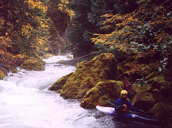
Putting in at the base of the dam, which is where the gorge begins. The first bouldery drop (with the undercut) is just around the corner from the rapids pictured here.
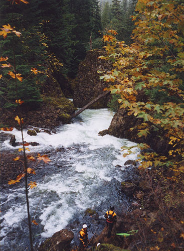
Galen Griffin (Griff) runs the second drop. The undercut boulder is on the
left, where the water is piling into it. I examined this boulder with no water in the river, and I noted that it sits on top of other boulders, creating a hazardous sieve. Nevertheless, it is pretty easy to avoid this spot.
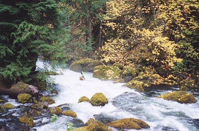
Just downstream we portaged a river-wide log and then the gorge began to assume a more class V nature, with a couple of longer, more constricted drops and no pools in between rapids.
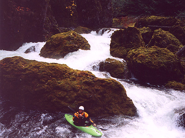
Josh below the single biggest boulder garden in the gorge.
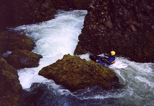
Below the rapid pictured above is another class IV rapid that leads to a couple more river-wide logs.
Josh gets a tailstand out of a big hole downstream..
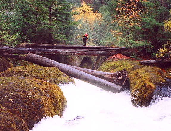
Just downstream were two river-wide logs. I got there first and climbed out onto the logs to provide safety in case anyone missed the eddy and got stuffed.
Griff eddies out above the two river-wide logs. I was standing on the logs when I shot this photo. These two logs would definitely move downstream with more water; they were new (as was much of the wood on this run) and would be flushed out by a significant high water event.
As we headed downstream we began to hear a rumble in the distance that grew into a roar as we hopped down through a series of smaller rapids. I scrambled out of my boat on the left and Josh got out on the right to scout above a huge horizon line with steam rising up from below.
I took a quick look and signaled to everyone else upstream: Five fingers up on one hand, one on the other.
Class six.
Portage.
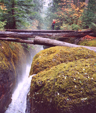
We had arrived at the Crack falls, and it was spectacular. Here the river churns down through a narrow channel that was spanned by two large logs, then it turns abruptly to the left and drops over a fifteen foot falls that plunges headlong into a fascinating (and scary-looking) narrow crack that is maybe ten feet wide. Most of the water plunges into the wall, but some goes to the right. Assuming you ran this OK (it is runnable, class V by itself) there is another nastier ten footer just downstream that drops into an even narrower, more powerful hole that looked pretty meaty, with very little water going downstream and a couple of logs at the lip to complicate matters.
This drop is runnable, but no one ran it on this day in either group. Everyone deemed this drop to be very dangerous, so we all opted for the easy portage on the left.
Josh Knapp scouts the Crack Falls. This is the lead-in to the main drop, where the river turns hard left and drops fifteen feet into the left wall, then turns and drops another 10 or so feet into the ugly hole against the right wall.
Josh again, peering down into the falls that plunges into the left wall on
the middle drop, which is where all of the steam is rising up from.
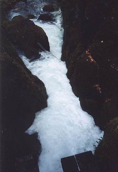
The 'runout' from the crack falls, as viewed from the bridge that Josh is standing on in the photos above. The pourover against the right wall is formed by a log sieve and drops about 8 feet into a really nasty looking hydraulic..
Below the Crack falls there are a couple of smaller drops, then we arrived at a monster horizon line that could only be Barrier Falls, named by the PGE fisheries biologists because it prevents fish from getting upstream.
Ever since I broke my back running Spirit Falls I automatically portage most waterfalls, so I shouldered my boat and headed downstream, portaging down the left side without difficulty. Griff and Steve also portaged right away. Pete and Kevin spent a little more time scouting, but in the end only Josh ran the drop.
He came charging over, plunged in, was under for a two count, and then popped up on the river right side and was pushed against the wall, but he had no problems getting off the wall. (Sam and Jed also ran this falls later in the day.)
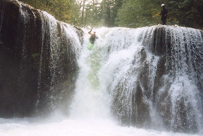
Josh Knapp drops over Barrier Falls while Kevin Nickel looks on..
Below Barrier falls (which is the end of the ~1 mile gorge section) the river eases to class three for the last 4 miles. There is a lot of wood on this section, but we only portaged a couple of times. For the most part we were able to limbo, sneak, or just shove the wood out of the way.
As we started to get closer to the take out we started seeing a lot of people on the riverbanks, all PGE employees and fisheries workers. Hopefully this report and the photos in it will raise awareness about this river, and possibly lead to future releases or at least a gauge on the river so paddlers can determine when it runs naturally!
Special thanks to Portland General Electric, who made this
release and our access to the river possible.