
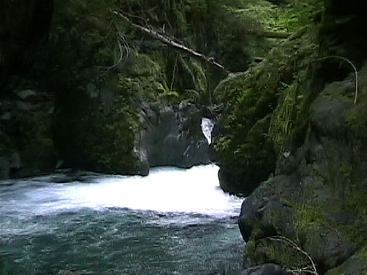
The gorge walls tower over my head and the rain pounds on my helmet. The only sounds are of the water careening through the tight gorge walls, no way up and no way out. I try to sit higher in my boat to see what’s past the next horizon line.
'The Place' is a quintessential diner somewhere around Olympia where we discuss our plan. The usual suspects are all there: Kris Wilson, Chuck Taylor, Trevor Shaw, and myself. “Hurry up and finish your oyster omelet - we gotta go,” I say to Chuck. Kris Wilson has concocted this plan that generally sounds like a rescue mission waiting to happen. We’re going to hike six miles into the North Fork of the Skokomish on the southeastern edge of the Olympic National Park. I ask Kris, “What do you know about the run?”
“Well, it’s been run before.”
“Really? What did you hear about it?”
“Well, that it’s runnable.”
“Great. When was that?”
“Um…a few years ago I guess.”
Two hours later we’re at the ranger station by the North Fork of the Skokomish. While paying the $10 per vehicle entrance fee to the park, the ranger sees our kayaks and immediately tells us to hold on, she’ll be right back. She comes right back with the park police. Great. We are immediately told that what we are trying to do is “a very stupid idea.” The officer repeatedly assures us that we will most certainly meet our untimely deaths somewhere on the river and that the park is not able to guarantee a rescue if and when we need rescuing. Someone goes on to assure the officer that, “We won’t need to be rescued, we know what we’re doing. We just watched a kayaking movie last night and it can’t be that hard.”
We then spend the next ten minutes assuring the park police that he was only kidding and that we’ve done this type of thing before. Shaking both head and finger at us, the officer reminds everyone in the truck that we are foolhardy people worthy of a reservation in the next Darwin Awards. Understanding that it’s the duty of the park police to keep visitors safe and informed, we assure everyone involved that we are quite capable and will play very safely. With the park officials mostly satisfied, we pass through the gates.
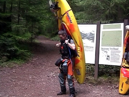
After toying around with various methods of carrying our boats along the trail to the put in, we get in a groove and are making good time towards where we figure a good put in spot will be. After enduring the baffled looks of backpackers and day hikers coming down the trail, we’ve covered the six miles to the put in after a few hours of intermittent sun and monsoon rain, typical Olympic Peninsula weather. It’s now 5pm. So much for getting on the water today.
We make the decision to stash our gear, scout a bit of the river, and then hike back in tomorrow morning and try to make our way to the take out bridge by the ranger station. Once we get to river level, we notice that it immediately enters an inescapable gorge. While being just the type of gorge that is unimaginably beautiful, it is also unnerving. One way in and one way out - in your boat, that’s it. We head back down the trail to the truck. By the time we get there, we’ve covered twelve miles in wet booties and our feet are a poor, foul smelling sight.
Sunday morning rolls around, bright and sunny…a perfect day to explore the relatively unknown. We get to the trailhead a bit behind schedule, but we’re fired up so we make good time on the way to the put-in. Since the gear is already at the top, we are able to haul ass up the trail.
Once again, the rangers appear from the forest, obviously curious about our unusual hiking garb. They have heard the rumors of kayakers planning to run the river. Turns out, these rangers are fully interested in our plans to paddle the North Fork. They’re so interested that they pull out the topographic maps to give us a better picture of the surrounding landscape. After a few minutes of friendly chatting, we decide it’s time to get going.
It’s warm and sunny, so with drysuits half on and no shirts, we head up the trail to our boats and the entrance to the gorge. People look at you really weird when your wearing a drysuit with the arms tied around your waist, no shirt, a funky looking helmet, and a bright yellow drybox in hand. We had some explaining to do on our way up just so they knew we were not astronauts. People are funny when you’re the weird one, ya know?
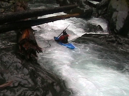
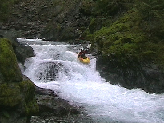
An hour and a half later, we are at the boats. The tension is mounting. We scout the first quarter mile of the gorge, which looks good to go, but fully inescapable. We chat with the trail maintenance crew who tells us of big boulders in the gorge that look truly frightening, log jams, and of the ranger who had fallen in and drowned. Thanking them for the beta, we lower our boats to water level. After a few delays, we are locked into the gravity and lure of the water. We begin working our way through the gorge. Within ten minutes, we enter what I would like to call “The Shit.”
The first section of the gorge that we had just scouted was not at all reminiscent of the character of whitewater that we are now faced with. Topographic maps indicated that this six mile stretch of river drops between 800-900ft between our put-in and the take out. We soon find that it loses the majority of this elevation in the first four miles creating an average gradient of just over 200fpm, which is fun and manageable. Formed by slabs of rock that had fallen into the river from the gorge walls, the rapids increase in size and intensity creating tight boulder gardens that are accentuated by sieves, siphons, undercuts, pin spots, and blind drops.
Scouting is becoming difficult and unnervingly committing. We are past the point of turning back with the only way out being down river. Working our way through the drops, we play a game of “river chess” hitting one boat eddy after one boat eddy. Often faced with hopping out of boat onto a boulder in the middle of the river looking down stream, we become more and more entranced and in tune with how the water moved. In the midst of several class V moves, we approach the biggest horizon line yet.
The river drops out of site appearing to bend around a corner far below our line of vision. Hitting the eddy just above this horizon line, we advance one at a time. The first person out looks down river from this mid-stream perch, gorge walls rising vertically above us. The signal of a portage gets relayed up river. Shit. How do we make this work? The rain begins falling so hard at this point that if you are out of your boat too long during a scout or portage, it requires draining before getting back in. Olympic Peninsula sized monsoons in May… awesome.
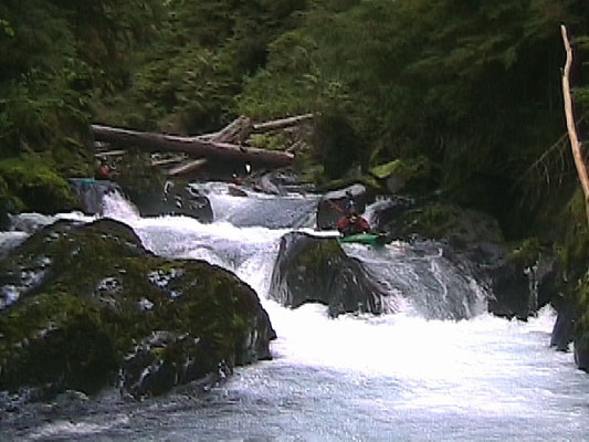
With some creative rope work and chest deep wading/swimming, we portage our way ten feet to a slight shelf on river right. Twenty minutes go by as we edge out boats around two wood choked waterfalls that would have been horrible encounters should there have been no way to portage. Just below them, we seal launch back into the water. Rapid after rapid, classic in nature, we work our way farther down stream, gorge walls unrelenting, our anticipation and grip factor increase. As my ability to keep a poker face on in the midst of a seemingly endless gorge filled with blind horizon lines wanes, the walls began to open up. We’ve made it through the gorge!
It was now 4:30pm and we bounce down through fun class III and IV drops for what ends up being about 100 yards. Now we descend into the second gorge and our progress once again slows. As we make our way through the initial drops in this second gorge, the vertical walls rise away from the water and the pounding rain has no problem finding it’s way down to our heads. With roughly three and a half hours of daylight left, it is nearly dark in the gorge of the North Fork of the Skokomish. The requirement of making good time through the gorge is accentuated by the increasing darkness and unrelenting rain.
We put the video camera away at this point, not worried about getting footage anymore. We make one more portage around a most likely runnable slide…but it has strange things going on in the middle that resemble an undercut ledge, sieve, and an ever narrowing crack that the river flows through at it’s exit. For safety’s sake, we walk it without much deliberation. After another fifteen or twenty minutes of an incredibly fun succession of class IV+ drops with only a few hazards, we exit the second gorge.
To our surprise, we spend the next several hundred yards on relatively flat class II water. I check the altimeter, which indicates that we still have roughly 400 vertical feet to drop before hitting the take out elevation. This makes us just a bit nervous. Is there another steep gorge? A big waterfall? What is in front of us that would allow that type of elevation loss? We have no idea but full of curiosity and with no option to hike out, we keep paddling. Sure enough, the gorge walls soon engulf us again. Entering gorge number three, we all grin at each other. The anticipation that is often associated with the unknown is being replaced with the realization that we are experiencing an epic, classic river that is a truly remarkable place. With the unknown in front of us, and the walled in waters of the North Fork of the Skokomish carrying us farther down river, we enter the third gorge.
The third gorge is much like the previous two, but not quite as steep. Not being quite as steep catches up to us at the end though. We eddy out on river left just above the biggest horizon line of the day. The left bank is made of house-sized boulders that have fallen from the gorge rim. As we climb on top of the closest boulder, we peer down into what requires a fourth portage. The first part is a clean ledge boof of about fifteen feet, which lands in a turbulent pool draining through an enormous sieve. To top it off, two of the largest old growth logs I’ve ever seen are jammed into the drop between the gorge walls creating a sieve/strainer combo of epic proportions. This is an amazing sight! Very large features in every sense of the word. We spend the next twenty minutes roping our boats up and then down the boulders along the left bank, finally reaching water level again. This drop signals the exit of the third gorge.
For the next mile, we paddle class I-II water through a flood plain the makes us witness to the powerful high water events that tear through the lower valley of the North Fork Skokomish. I gawk at the massive old growth logs and landscape that are scarred by the annual floods. After one quick log jam portage, we are at the final series of rapids near the ranger station. The entrance drop pours over two drops created by enormous rows of boulders, only to be sieved out at the exit of each drop. A quick portage puts us back in that water above the final two big boulder gardens. Scouting proves them both to be runnable and they contain some of the best rapids of the day. I’m finally able to test the rodeocreeking ability of the M3…lets just say that it performs in a manner that I am happy about ? and allows me to finish the final boulder garden in a clean manner. As the clouds start to give way to evening skies, we round a corner and see the take out bridge. We’ve made it. It is 7:40pm and we are so fired up about the last two days, we can’t stop grinning. Ten minutes later, cold beers in hand, we are recapping the events of the past two days…
…Eighteen miles of hiking, blisters, baffled backpackers, trail crews wishing our safe passage down the river, very friendly park rangers that helped to increase our understanding of the area, good weather, bad weather, miscommunication, incredible teamwork in an unforgiving environment, and six miles of some of the most incredible landscape I’ve ever seen…
Today I spent my lunch break at work looking through topographic maps of the Olympic Peninsula. We’ve got the next mission picked out and if I make it there this weekend, it won’t be soon enough.
Written by Bryan Youngs
Email (spelled out to prevent spam): rodeocreeker at yahoo.com