You hear the North Fork long before you see it.
Stories. Photos. Top Five lists. Videos. Magazine Articles. Guidebooks.. All of the talk, the build-up, none of it will prepare you for this river when it is running high ( 3,000 cfs ). The North Fork Payette is one of the most feared and respected class five rivers on the planet, and it deserves that reputation!
We were on our summer trip to Idaho, and after a few glorious days paddling the headwaters of the Salmon, we headed for the Payettes. We were a mixed group, some interested in class IV, others with no discernible upper limits. At this point of the trip I was riding in the van with Jesse Coombs, and we had lagged behind the rest of the group because we wanted to check out the upper sections.
We arrived at the lake that feeds the North Fork, and I felt as if the air was charged with electricity, like lightning had just struck nearby. "I've waited a long time to see this river." I said to Jesse.
We drove past the more difficult upper reaches first. The river was running high, with nearly 3,000 cfs thundering downstream through a 30-foot wide channel littered with jagged granite boulders from road construction. Now, kayakers from Oregon are not accustomed to seeing that much water crammed into such a narrow, high gradient riverbed, so the North Fork was an awe-inspiring spectacle for me.
At 3,000 cfs and above the guidebook rates the upper sections V-VI, and it deserves the rating. Words are not adequate to describe what we saw there. After several near misses with oncoming traffic as we gaped at the whitewater of the upper, we pulled over and started scouting drops.
"Holy S--t." I thought to myself. "This is insane.."
Of course, Jesse was all smiles as he scoped out the maelstrom below us. "Let's put on right now." He said excitedly. "We'll catch up to those guys at the bottom.."
I just stared at him in disbelief. I was almost 100% sure I would be torn to pieces within minutes of putting on this river. I had literally never seen anything like it.
Jesse has run the entire North Fork top-to-bottom and would have put on without a second thought ( see earlier comment about upper limits ) but nobody else in the group wanted any part of the Upper North Fork at high water.
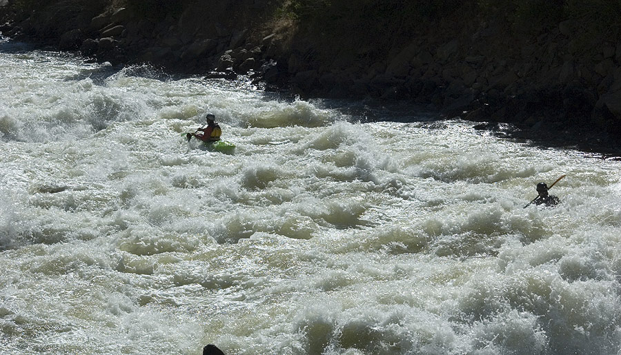
Eight paddlers have drowned on the North Fork Payette in the last twenty years and many more have been injured. The river is narrow, powerful, and steep. The road construction crews dumped countless razor-edged granite boulders into the riverbed, turning the river into a merciless meatgrinder for paddlers who fail comply with the First Commandment of the North Payette: "Thou Shalt Not Swim.."
There are no waterfalls or ledges on this run, at least not that I could see. Every rapid seemed to be formed by giant piles of jagged granite boulders which barely seemed able to contain the raging water. The narrowness of the river and the volume of the water combined to form huge features: Giant holes, pour-overs, and exploding waves, and rapids that seemed to go on forever. All of this kept us driving downstream, faces pasted to the windows..
As we drove downstream, we saw no sign of other paddlers, no shuttle rigs, no one in the river. It was a perfect day for paddling, but nobody seemed to want any part of the Upper North Fork that day.
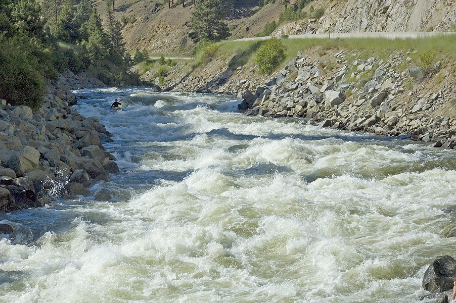
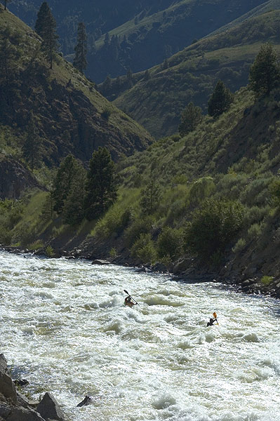
Finally, we arrived at what locals refer to as 'The Lower Five', which is the lower five miles of the North Fork starting at Hounds Tooth and continuing down to the confluence with the South Fork.
The Lower Five is the easiest of the three North Fork sections ( though it is still class V ). This section looked somewhat more reasonable to us, but was still very tough in places. The river is much wider here than on the upper section, and there are only three big class V rapids in five miles, with long cruising sections punctuated by relatively smaller drops in between. Now things were looking more reasonable, and everyone perked up and started thinking that we all might want to give er' a go.
This enthusiasm only lasted until we scouted the big one in the middle, known as 'Juicer', where a truism about the North Fork became glaringly evident: The rapids on the North Fork are so long that portaging isn't really an option, so if you aren't willing to run every drop in a particular section, you shouldn't put on. In this case, The Juicer was the drop that kept most of us off the Lower Five.
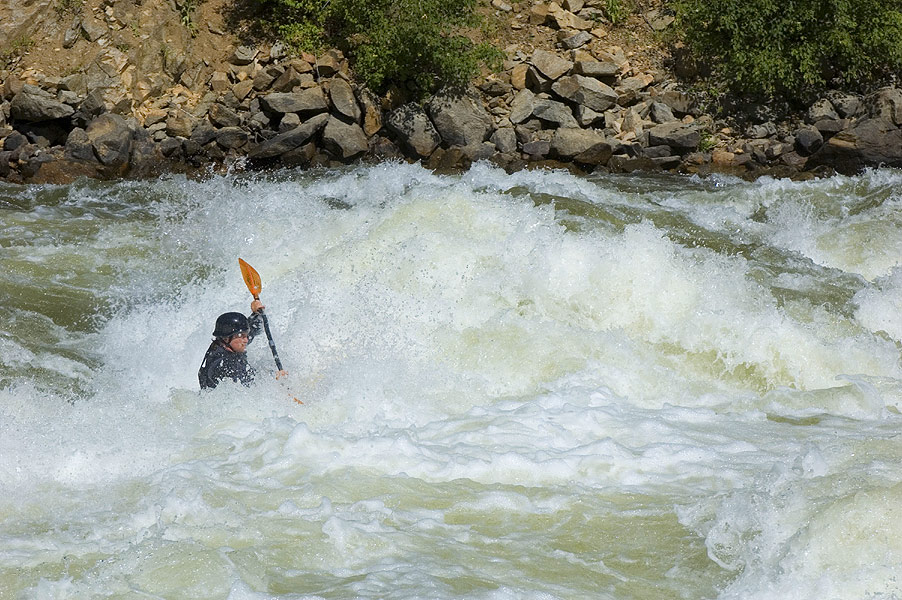
The Juicer is about two hundred yards long and is named for the huge, retentive hole exactly halfway down the rapid. Most of the river sweeps around the corner into this hole, and if you end up in it at the high flows we had you're pretty much going to swim forever or until you sprout gills, whichever comes first. At high water the hole recirculates from ten feet downstream, and it looked pretty much unpunchable on the river-left side, where most of the river is going.
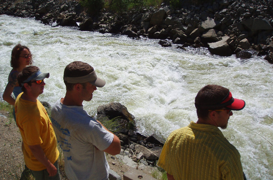
( From left ) Grace, Conor, Jesse, and EJ ponder the considerable gravitational pull of the Juicer Hole at high water.
Most of the river sweeps around the corner with big features leading directly into this giant hole, which recirculates from ten feet downstream..
After contemplating the considerable gravitational pull of the Juicer Hole and listening to a local kayaker tell of his near-drowning in the hole at half the flow, the group had once again dwindled down to two who were still willing to run the whole five miles: Jesse and Bob.
The rest of us decided that we would be perfectly content to provide safety, take photos, and perhaps come back sometime when the water was a little lower and the lines a little more forgiving for a first-time run.
At this point we drove off and ran the Staircase section on the South Fork Payette, just upstream of the confluence with the North Fork. The South Fork was also booming, with around 3,000 cfs as well, and it was super fun! We did have a swimmer in Staircase Rapid when one member of the group fell into the massive hole in the middle of the river, but other than that it was good times and great surfing all around.
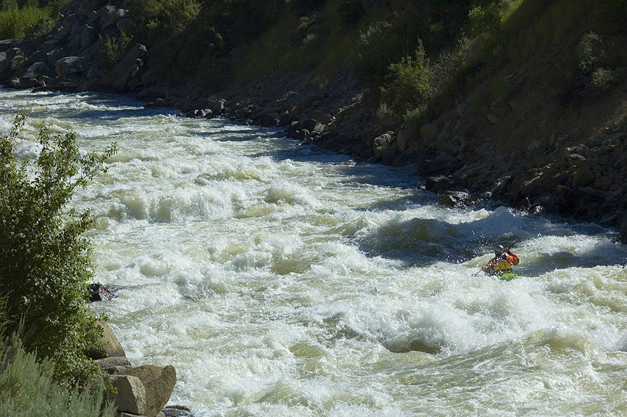
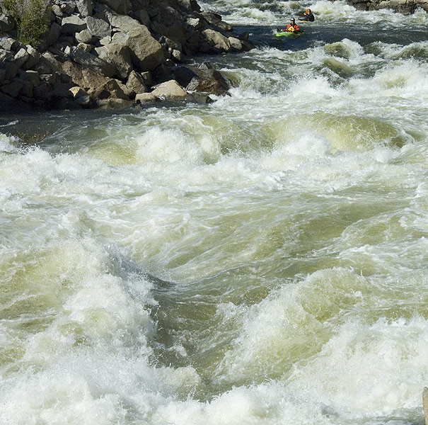
Now that the rest of us had our whitewater fix for the day, we drove back up to Hounds Tooth so that Jesse and Bob could get theirs. We set up at Hounds and watched as the boys cleaned up on this big two-part drop as expected, and then we headed up to the cars. Our next stop was The Juicer, where we planned to set up three ropes and a harpoon gun at the Juicer hole in case someone ended up it.
Jesse Coombs partway down Hounds Tooth at high water, lining up on the hole shown in the next photo..
photo by EJ Etherington
Bob Lee threads the needle between two huge holes in the middle of Hounds Tooth at high water.
photo by EJ Etherington
Just above Juicer the experienced local kayaker that had been guiding Jesse and Bob down decided to take out. He said the river was too high and since he had nearly drowned in the Juicer hole at half the current flow, he didn't want to go anywhere near it.
Now Jesse and Bob were on their own, with the toughest part of the river ahead. Of course, they decided to keep going, so we headed downstream to set up the harpoon gun at Juicer hole.
The tricky thing about the North Fork road-scouting-wise is finding the right pull out without becoming a hood ornament for an oncoming semi truck. I managed to completely botch the planned parking spot at Juicer so we were forced to run back upstream for several hundred yards in the withering summer heat. We arrived at the rapid in plenty of time to set safety and gaze longingly at the water as the sweat poured off our bodies.
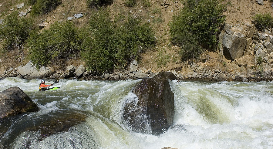
Bob Lee enters the Juicer. About one third of the rapid is visible here. The entire river sweeps around to the river-left just below this photo into Juicer Hole. You have to get river-right ( and, more importantly stay river-right ) in order to avoid getting 'juiced'..
photo by EJ Etherington
Both Jesse and Bob managed to stay river-right and avoid the Juicer hole ( not an easy thing to do! ) and we breathed a collective sigh of relief then jogged back to the cars.
Jesse Coombs enjoys the relatively mellow runout below the Juicer hole.
photo by EJ Etherington
The last big drop on the Lower Five is known as 'Crunch', a rapid that seems to go on forever. Crunch is easier than Juicer ( which is definitely the crux of the Lower Five ) but is still a pretty stout drop.
Jesse and Bob get ready to feel the power of 'Crunch' at high water.
Crunch the last big class V on the lower five, and at this flow it was about a quarter of a mile long.
photo by EJ Etherington
Bob and Jesse also cleaned up on Crunch as expected, and we all cheered when they reached the bottom of the rapid, far downstream and nearly out of sight..
Jesse and Bob try to stay oriented in the middle of 'Crunch'.
photo by EJ Etherington
Crunch just goes on and on and on.. Jesse and Bob continue down Crunch.
photo by EJ Etherington
The following day we did the classic South Fork Payette Canyon, and then afterwards Jesse hooked up with a couple of members of the Canadian Junior Freestyle Team and they did a high-water run in playboats down the Lower Five of the North Fork Payette.
This time Jesse ( who was in his Jackson Fun ) decided to run Hounds Tooth from the top ( the top of Hounds is not pictured in this report, and is guarded by a massive hole ) while the Canadian crew decided to put in below it.
Even though Jesse is a kayaking superhero, I was a little concerned because the first hole in Hounds is massive and the Fun is such a small boat. Of course, not to worry, Jesse made Hounds look deceptively like class three even in his playboat ( a common occurrence which I refer to as 'The Jesse Effect', which is when Jesse runs some disgusting rapid and doesn't get his head wet, which then inspires other unsuspecting kayakers to follow, usually resulting in the complete annihilation of the aforementioned unsuspecting kayakers.. )
We didn't get any photos of their run, and in spite of one very scary moment when one of the Canadians flipped upstream of Juicer hole ( and nearly got to test our various theories about how thoroughly it would pulverize a swimmer ), everything went smoothly..

At flows of 3,000 cfs and up, this river is full-on, big volume class five. I think medium flows would be much more reasonable, like 1,500 cfs or so. The North Fork is dam-controlled and runs pretty much all summer long ( with warm water, no less! ). You can find more reasonable flows in August, and I think this is probably when there are lots of paddlers on the river ( There is a pretty large Portland contingent that heads over to the North Fork every year around that time, when it is running in the 1,500 cfs range ).
A note on swims: At the risk of belaboring a point, you absolutely cannot swim the North Fork at medium to high flows. This river is flat-out ferocious! The rapids are long, violent, and powerful, and eddies few and far between. The granite is sharp from the blasting during road construction, so any swim is pretty much a life-threatening experience.
On a more positive note, access and scouting is easy, because the entire fifteen miles is roadside. Much of the upper crux section is obscured by trees though, so scouting ahead of time is somewhat tedious ( and ultimately futile; you'll never remember the lines on the upper once you're in there, so find a local and follow them down.. ). The nice thing about the road being so close is that you can run as much or as little of the river as you want, with put-ins and take-outs all the way down the river.
For more info, pick up a copy of Grant Amarals guide to Idaho Whitewater, an essential and thorough resource for all paddlers interested in this state. Grants book is Idahos' version of the California 'Bible', and is just as informative and entertaining as the Stanley/Holbeck guide.