Upper Willamina: Upper Willamina Falls to First Bridge: 3 miles, 162 fpm, continuous, class: IV
Lower Willamina (the beaver section): First Bridge to Lower Willamina Falls: ~4 miles, 80 fpm - continuous, class: II-III

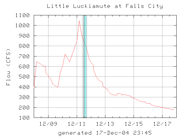
12/11/2004
Upper Willamina: Upper Willamina Falls to First Bridge: 3 miles, 162 fpm, continuous, class: IV
Lower Willamina (the beaver section): First Bridge to Lower Willamina Falls: ~4 miles, 80 fpm - continuous, class: II-III
Pete Giordano and I stumbled across Willamina Creek after running Rickreall Creek with Gabe Flock last year. We were wandering around in the coast range, checking out new streams, and we ended up in the Willamina Creek drainage.
Much to our surprise, we found ourselves on a bedrocked-out creek, with a couple of significant rapids visible from the road. We started heading upstream, and were amazed by the beauty of Willamina Creek Canyon, and the steepness of the walls. By the time we arrived at the upper bridge, we saw that the creek ran away from the road, hooking around a small coastal peak, far out of sight. We spend some time scouting the complex and powerful fifty foot falls at the put-in for novelty's sake, and then peered down around the corner, where another large rapid appeared to begin before the creek dropped out of sight..
"Hmmm.." I thought to myself. "This one has some potential.."
Needless to say, we were highly intrigued and vowed to return the following year..
December 11th, 2004
It was the first big rain weekend of an otherwise anemic 2004 Fall season. Pete and I decided that this was the weekend, we had to run as much exploratory stuff as possible before the water faded away and the drought continued, so we decide to give Willamina a go.
On Saturday we rallied Jon Fowlkes out of Portland and the rest of team Ever-Ready out of Corvallis: James Bagley Jr, Jesse Coombs, and Michael Long. "I hope there are some actual rapids on this creek." I joked with James when we pulled up to the rendevous point near Rickreall. "It might be totally flat!"
Nobody thought that was very funny for some reason..
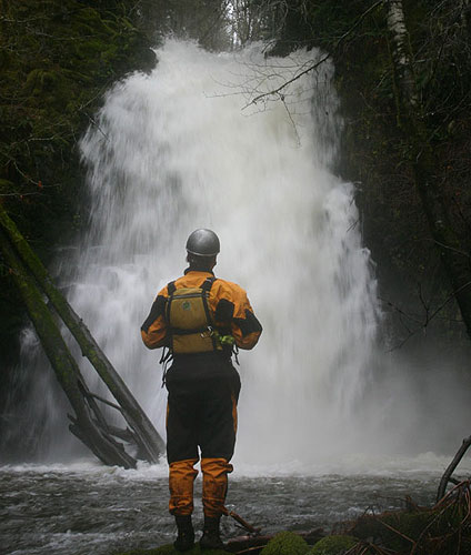
After running the shuttle, we began lowering our boats down the extremely steep 80-foot canyon wall, then carefully downclimbed to the base of the falls. Of course, Jesse spent awhile scouting the monster falls at the put-in, but in the end decided not to give it a go after Pete and I warned him about the boulder in the landing we had seen during our initial scouting trip. If the pool would've been deep enough, I think Jesse would've racked up another monster drop..
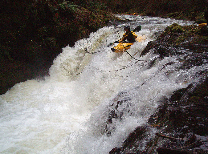
Jesse Coombs ponders the bottom drop on the monster 50-foot, multi-tiered falls at the put-in for Upper Willamina.
photo by Michael Long
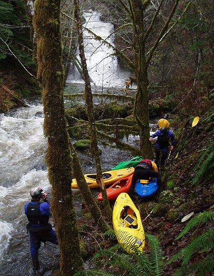
The put-in at the base of the steep canyon wall. Jesse is visible upstream, scouting the base of the multi-tiered 50-footer..
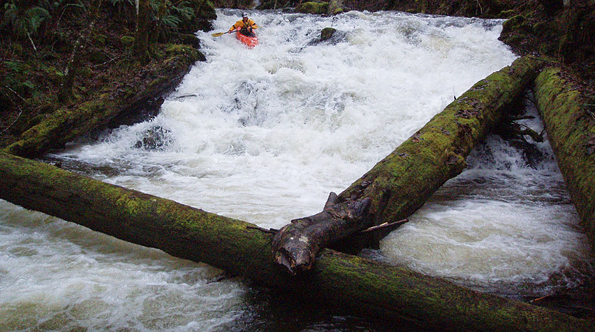
Pete and I had seen a horizon line just downstream, and sure enough we paddled about forty feet before pulling out at a big horizon line. Jon got there first and scouted on the left, while I scrambled down on the right side.
Below us the creek tumbled over a jagged fifteen-footer, blocked at the base by a couple of large, criss-crossed logs. I later dubbed this one 'Itchy and Scratchy', because the clean route on the left side is blocked by the logs, so you are forced careen down the right side and boof over the jagged rocks halfway down..
Jesse Coombs probes 'Itchy and Scratchy'. This drop requires a tricky limbo under the logs as soon as you run it..
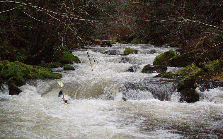
Pete Giordano (foreground), Michael Long and James Bagley Jr. (background) run the fun series of slides below Itchy and
Scratchy.
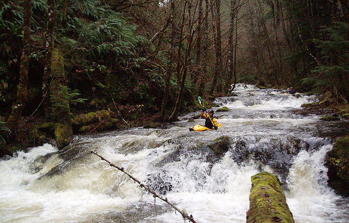
Below Itchy and Scratchy the creek rolled right along with a long series of small slides and little ledges, very fun stuff!
Pete Giordano probes a fun ledge halfway down Upper Willamina. Too much fun!
Below the ledges section the creek mellowed a bit, with lots of smaller rapids and some little playspots. The scenery was really nice though, and the creek was very twisty, which kept us on our toes. Finally after about a half mile we arrived at the long boulder garden section, which consists of about a quarter mile of class III-IV boulder gardens piled on top of one another, really high quality stuff!
Michael Long disappears into a hole in the middle of the long boulder garden section around the middle of the trip..
Below the long boulder garden section the rapids tapered off somewhat, and the creek started opening up as we approached the take-out bridge for the upper section. We had decided to take out at lower Willamina falls downstream, so we kept on going past the bridge.
Lower Willamina Creek below the bridge is kind of a mixed bag; in places it is stunningly scenic, with huge cedars and quiet, mossy meadows. On the other hand, the gradient is half that of the upper section, so the rapids are small and infrequent. There are about three excellent play holes at the flow we had though, and some of the smaller rapids were kind of fun.
Oh yeah, we actually saw three beavers in the lower section of the creek, so we nicknamed this 'The Beaver Section'. Those little fellas have been pretty busy on this stretch, so expect to portage maybe five times around logs and small logjams..
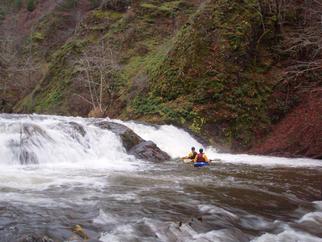
At long last lower Willamina Falls appeared, and we had folks run both the right and left sides of this falls, which is clearly visible on the drive up. This is a handy spot to take out for the lower section, because there is a place to park and there is a very well-developed fishman's providing easy access to the creek.
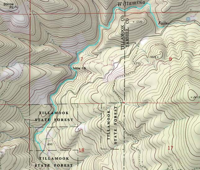
In the end, we all agreed that Upper Willamina doesn't rank among the best creeks we have run because the rapids were not consistent enough, but overall the creek is certainly worth running at least once. Lower Willamina, on the other hand, was pretty disappointing. It is much more scenic in places than the upper, but the rapids are poor and the logs much too frequent. I can't really recommmend running the lower section at all. If you decide to paddle Willamina Creek, I recommend that you only do the upper three miles and take out at the bridge shown on the map below.
Pete and Jon below Lower Willamina Falls, which marks the take-out for Lower Willamina Creek.
Most of the group
ran this falls on the far left, against the wall pictured here.
FLOWS AND DRAINAGE MAP
FLOWS:
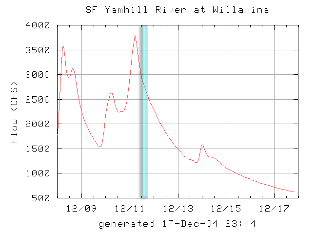
Willamina only runs after BIG rainstorms. You need at least 3,000 cfs in the SF Yamhill at Willamina and 800 cfs
in the Little Luckiamute at Falls City. The flow graphs for the day these photos were taken are shown below. I think you
could double these flows and the creek wouldn't get much harder as most of the major rapids are quite wide open, no narrow
drops anywhere.
DRIVING ACCESS
Take Highway 99 through Salem and turn on Highway 22, then Highway 18 towards Willamina. Willamina Creek comes in on the North side of town, follow the main road out of town up along the creek.
An overhead view of Upper Willamina Creek. Put in just below the falls marked on the map, take out three miles downstream
at the first bridge. The four miles below this has three excellent play holes but not much else until you get to the lower
falls..
History of Willamina Creek Paddling:
It is not known at this time who else has run any or all of this creek. If you have any information about previous descents, please let me know so they can be included here.