Sweet Creek
Oregon Coast Range
Torture Factor: Sets a new low
Click here to watch the video
trip report for this creek.

Copyright © 2006, Oregon Kayaking.
No part of this page may be reproduced, linked, or copied without the
express written
permission of the Oregon Kayaking webmaster.
There may not be a more appropriately named creek anywhere.
Sweet Creek ( yes, that really is its name! ) is a creeking playground, featuring a superb series of ledges and falls packed into a very short distance. The Corvallis-based exploratory kayaking guru Dan Coyle first discovered this little gem back in the nineties, and ever since kayakers have been trekking across the coast range when the rain falls hard.
Sweet Creek is popular with both kayakers and hikers, but for different reasons. Hikers and photographers flock to this creek to soak up the wonderful coastal rainforest scenery typical of the Siuslaw National Forest, while Kayakers will find their eyes drawn downward, towards the siren song of steep, powerful drops.
A better name for this creek might be 'Short but Sweet Creek' because the good stuff is packed into a short, action-packed gorge. That said, access is so easy that paddlers do laps in the lower gorge, so you can pack a lot of boating in one day if you are motivated!
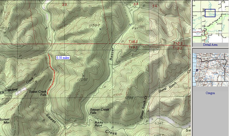
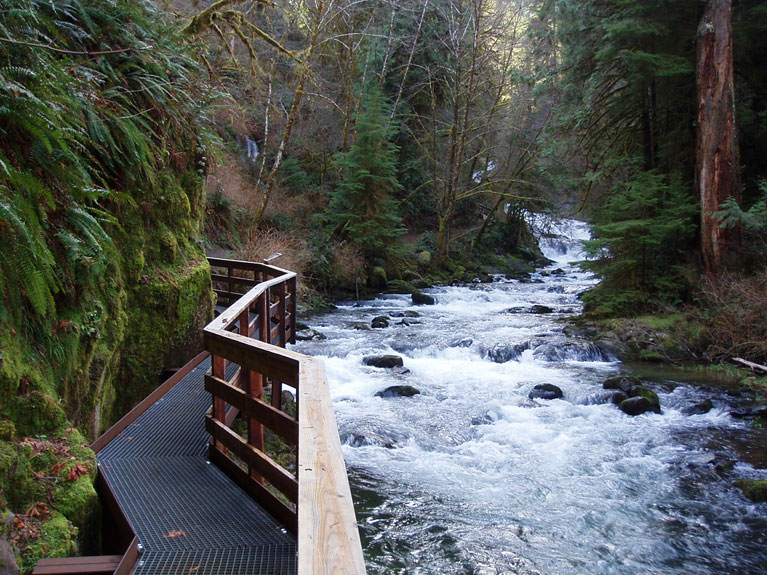
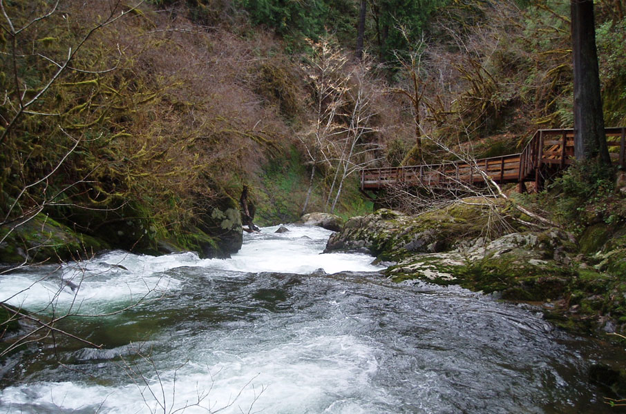
The lower gorge is a short hike up a well-maintained gravel trail from the parking lot. The state park service trail-building team must've been especially motivated on this one because the gorge walls didn't faze them, they just suspended walkways from the walls above the creek..
The suspended walkways lend an air of unreality to Sweet Creek, because you can stroll along and examine each drop with ease, then cheer your buddies as they claw their way out of the holes. It's over in a hurry, but there's no line at the top for this ride, so you can keep hauling your boat back up the well-manicured trail until your legs give out or you get the ol' Sweet Creek beat down..
The walkways also mean you will encounter many fellow nature lovers who will gape at you and say goofy things like: "Oh my, you're not going in THERE are you?!?." or my personal favorite: "Are you going to kayak this RIGHT NOW?!?" Ummm.. yes.
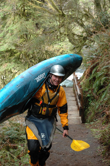
Jesse Coombs motivated for a fun-filled day on Sweet Creek..
photo by EJ Etherington
According to Eric Brown's description in 'Paddling Oregon' it is possible to drive to an upper put in for this run, but the vast majority of paddlers hike up from the parking lot and only paddle the lower gorge. The upper section is much wider and requires more water, so when the upper has plenty of water the lower gorge is generally too high, and conversely when the lower gorge is at a good medium flow the upper is too low.
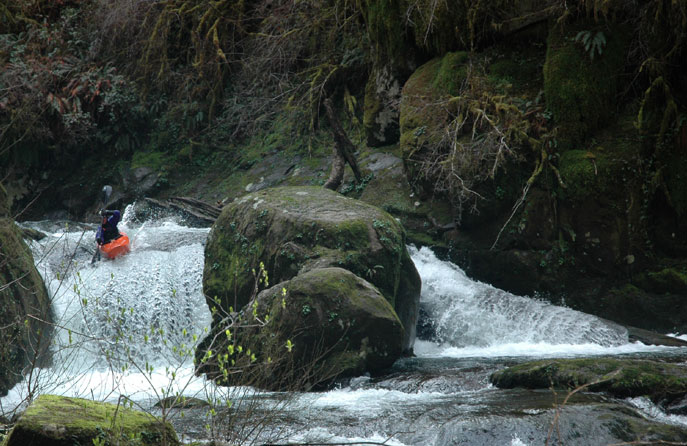
The first glimpse of Sweet Creek gorge..
On this trip we had EJ Etherington, James Bagley Jr., Jesse Coombs, and myself. The weather had cleared off nicely after a few days of rain, so it was a very pleasant day. The hike up from the parking lot takes about ten minutes on a mostly flat gravel path. We arrived at the put in and James decided to go first, so the rest of us got set up for photos and video..
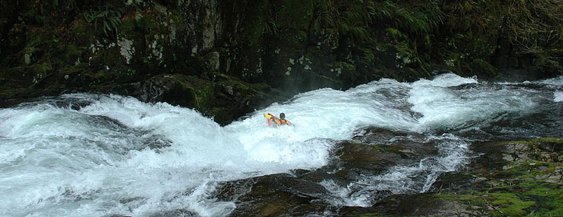
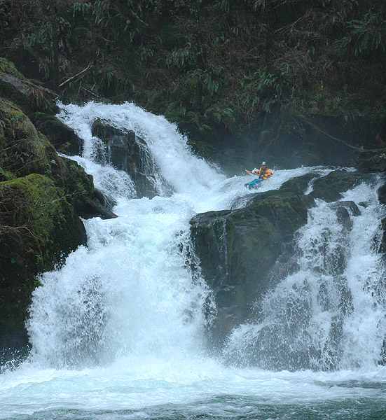
The put in at the top of the gorge. There are five major ledges and falls in the gorge, with steep slides in between.. it's one heck of a ride!
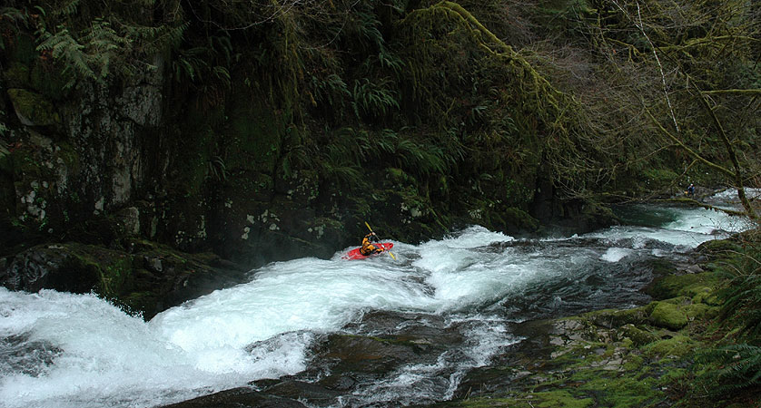
James came bombing down and had a very clean first run through the gorge. After he eddied out, he got out of his boat and got set up on a ledge downstream so he could shoot video looking up into the gorge.
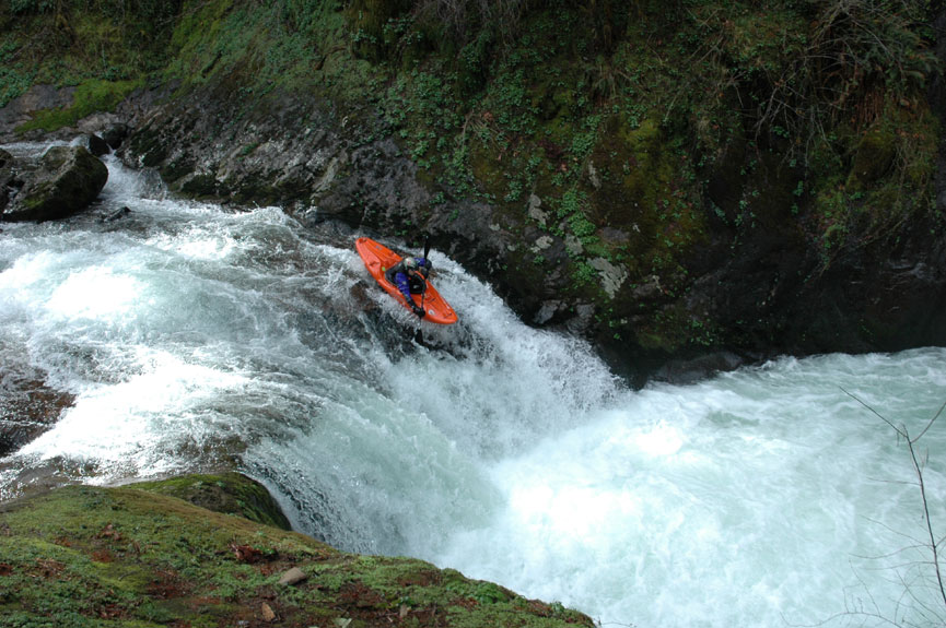
James Bagley sets up for the boof on the right side of the boulder drop in the gorge. The sides of this drop are undercut and have swallowed paddlers up in the past, so make sure you land this one well clear of the curtain..
photo by EJ Etherington
James digs in for the boof just downstream..
photo by EJ Etherington
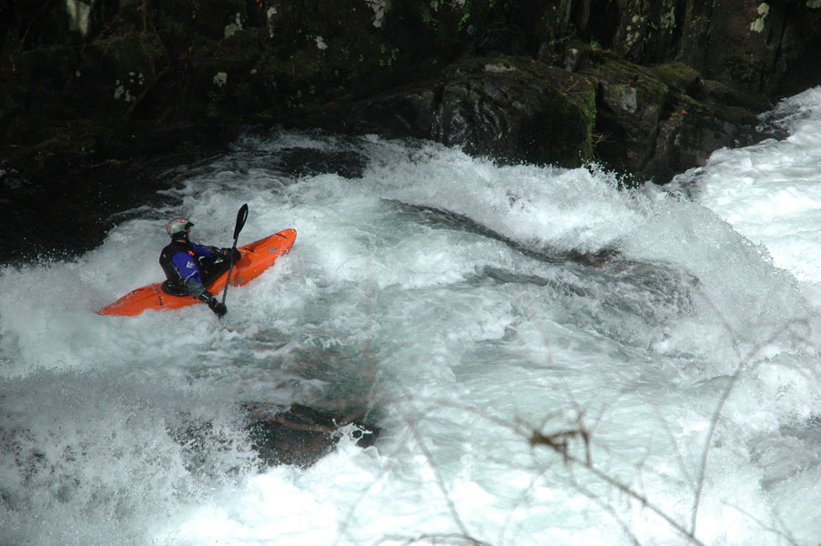
James lines up on the crux middle ledge in Sweet Creek Gorge. This ledge is most likely to cause problems for paddlers due to it's irregular shape and steep, fast lead-in.
photo by EJ Etherington
Once James finished his run EJ went up to the top of the gorge to get ready while I set up to take video. ( Jesse had gone upstream to scout Sweet Creek Falls, the hideous 30-foot double drop on the upper section, so he ended up being last in line this particular day ). EJ came bombing down after a couple of minutes and also had a clean run. I was up next, so I hiked up, got ready and dropped in. I had clean lines as well, what a great ride!
A wide angle sequence of the author running the bottom two ledges.. Here I am lining up on the crux middle ledge. The right side of this drop goes into a deep, narrow crack, so stay left on this one..
photo by EJ Etherington
The author, straightening out below the crux middle ledge..
photo by EJ Etherington
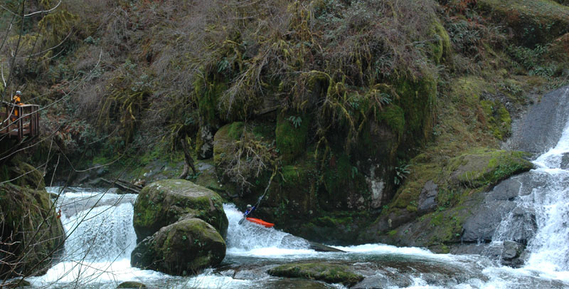
The author approaches the bottom ledge. This drop is actually a little deceptive, because there is a second, uniform pour-over just downstream that tends to surprise paddlers who don't come through straight.
photo by EJ Etherington
At this point Jesse had come back from scouting Sweet Creek Falls on the upper section, and he took a couple of laps in the gorge as well. On his first lap he ran the right side of the second ledge, completely disappearing for a long count in the crack on that side.. ( see the video ) expect lots of down time and a likely flip if you run that side..
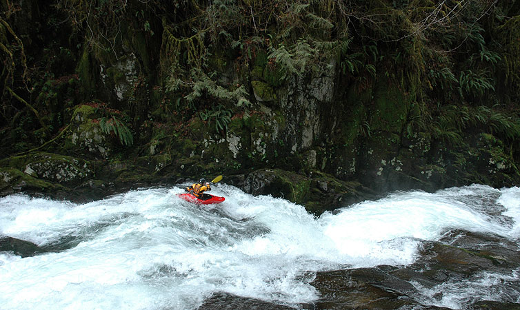
James opts for the left-side log slide in the second drop in the lower gorge.
photo by EJ Etherington
After many laps in the lower gorge, we started to wind down a bit, and Jesse said he wanted to go up and run Sweet Creek Falls. We weren't too surprised at this, so we stashed our gear and headed upstream to see what the upper falls was all about.
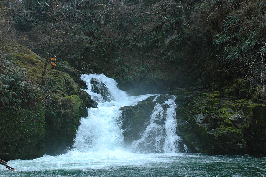
Sweet Creek falls is about a mile upstream of the lower gorge. When we arrived my first reaction was "This drop is sick and wrong.. The first drop is sick, and the second drop is just wrong.." This falls is really nasty, with rocks in all the wrong places if you know what I mean.. Jesse borrowed my elbow pads because the second tier of the falls careens off of a nasty-looking fang rock, and he headed upstream with James.
Jesse scouts Sweet Creek Falls
photo by EJ Etherington
While Jesse scouted the falls, EJ and I reviewed our plan if he was injured running the drop. We located a couple of small, sturdy logs we could rig up as a stretcher if needed, and we decided ahead of time where we were going to stage him by type of injury. We talked it over so there would be no confusion. "If he does an ankle, we'll put him on those rocks over there while we splint him up. If he does a shoulder, we can stage him on this boulder and reduce it on this side.." and so on.
The thing is, you gotta be ready for anything. You don't want to figure out what to do after things go wrong, no matter how unlikely that may be.
After a few minutes we heard a whistle and I caught a flash of paddle blade as he shot over the first drop and made the surging eddy against the creek-left wall.
"He's in the eddy!" I shouted to EJ. "Here he here comes!!"
And then Jesse was charging out of the swirling pool between the drops, down into the bottom falls. He got blown to the right slightly on the lead in to the final drop but corrected with a stroke at the lip and plugged the bottom drop perfectly, melting down and emerging in the pool below, upright and grinning as he always does after he cleans up on a hideous drop..
Jesse Coombs lines up on the second tier of Sweet Creek Falls
photo by EJ Etherington
Flows, Access, and Map
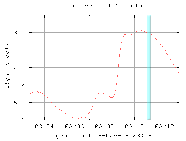
This creek is fed purely by rain. The nearly Lake Creek gauge gives a good correlation, generally 8.5 feet to 9.5 feet after a rainstorm is a good range. Above 10 feet the holes start to retain, though it has been run much higher by a few locals.
Sweet Creek has a tiny drainage, so rainfall runs off fast. Also, Lake Creek is huge with many tribs, so it holds water much longer than Sweet Creek after a rain event. Therefore, the closer you are to the rain event, the higher the creek will be, so 9.0 on the internet Lake Creek gauge and raining will mean more water in Sweet Creek than 9.0 feet on the Lake Creek gauge two days after a rainstorm.
The graph below shows the flows the day the photos in this trip report were taken. This is considered a medium-low flow.
Here is a map of the main run on Sweet Creek. You can also put on upstream and run the Beaver Creek variation, which has another 18 foot falls.