
There are strict rules against ascending or descending the creek banks within the park- you may be cited by the park service if you are caught, so don't do it! The creekside ecosystem is very delicate, so scout carefully and don't leave the creek once you are on it. (Note: Be sure you put in below Lower North Falls- for more details see the Upper Silver Creek trip report on this site.) Just downstream from Lower North is a nice warm up ledge that gives you a good idea of what waits downstream. Below this first ledge are several more like it as the creek winds it's way down through a deep, lushly vegetated canyon. Logs have been a problem down here in the past, so be sure to scout all blind drops.
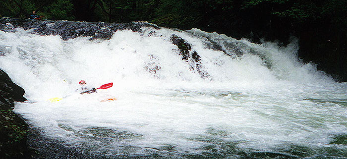
Mike Haley runs the first of several sizable ledges on lower Silver Creek.
Below these smaller ledges is the confluence with the South Fork of Silver Creek. Just below the SF is Crag Falls, a 10 ft ledgy drop that has a long, low angle slide leading into it on the right. This drop can be scouted on the left. This drop used to be choked with logs but when we did it in the Spring of 2000 it was had a log or two but nothing too bad.
John Whaley runs Crag Falls. Note the log just downstream- it's not a serious hazard for non-swimmers.
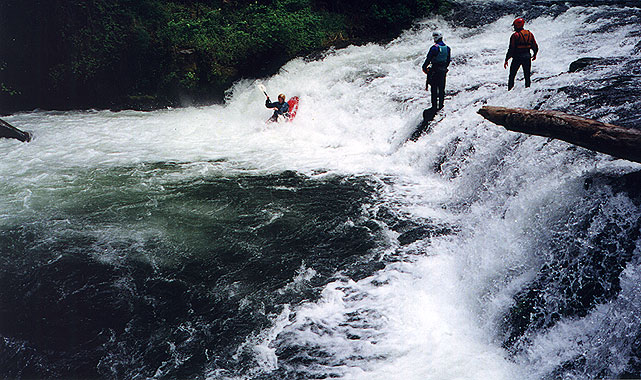
Below Crag falls the creek is mellow for awhile and then paddlers arrive at Dobo Falls, a steep twelve foot plunge preceded by a couple of small ledges. Be sure to catch the eddy on the left above the falls to scout! The best line at Dobo is a boof on the left, but this line is complicated the fact that most of the current flows perpendicular to the lip of the falls down into the ugly fold on the right side. When we first got to Dobo John went first and demonstrated the best way to run this one- he eddied out just above the falls and then did a strong ferry across the current at the lip of the drop and boofed cleanly on the left.
Ely went next, and when he caught the eddy he got pushed against the wall so when he came out of the eddy he was too far right with not enough speed. I was downstream and I saw Ely get swept down into the fold and disappear with a thump into the nasty hole at the bottom! Everyone froze as the seconds ticked by and Ely failed to materialize in the pool below. After at least five long seconds (an eternity at the time...) Ely surfaced upside down in the pool below and rolled up. "Man, there was a ton of water pressure down there!" he said later. "It just kept pushing me deeper and deeper!"
Ely wishing he were somewhere else at Dobo Falls.
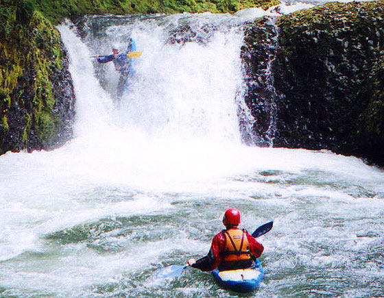
He of course wanted to run it correctly so he climbed back up and ran it again with much the same results. Not one to be easily discouraged, he dragged his boat back up and on the third try had a perfect line and didn't even get his helmet wet!
Just below Dobo is Canyon Falls, a small slide that is a little difficult to scout due to the steep rock walls but can be run any way you want with momentum. Just over two miles below the confluence with the South Fork is the boundary of the State Park. Once you leave the park look for a green steel bridge over the creek. Just below this bridge is a 4 foot ledge that can develop a sticky hole on the right at some flows.
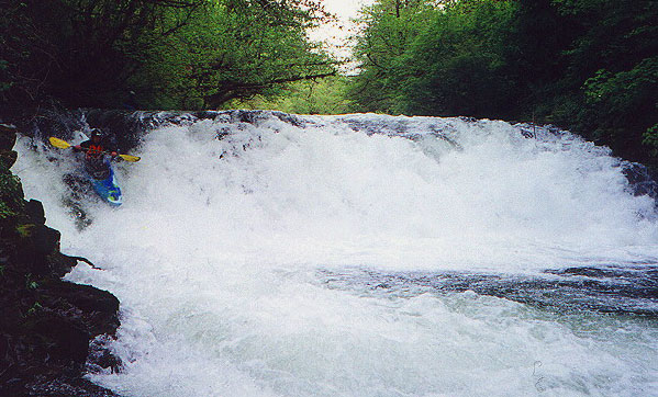
A quarter mile below the bridge be on the lookout for Dirty Falls. This ten foot ledge is a no-brainer if you take the slide down the right side. Be careful above Dirty as there is a fast class two drop leading into it- alert paddlers will be able to see this one in time so stay on your toes, especially at higher flows. There are eddies on the right but it would be easy for a boater to get blown into this drop. Scouting on the right requires some bushwhacking but it is worth a peek to be sure there is no wood.
The author runs Dirty Falls.
Below Dirty Falls the creek gradually slows and the last four miles or so is mellow class II with one steeper drop known as Murrays Slide. This fun drop has several parts and can be boat scouted at medium flows or bank scouted on either side if necessary. Below this ledge it is a quarter mile to the flat water paddle out across the reservoir. The first time we did this run I had broken my boat on the upper section so I had to sprint across the reservoir as my boat slowly filled with water...
Flows: This creek runs fall through spring after a couple of days of heavy rain. Because this run has a relatively low drainage, it is totally rain fed and does not have a spring snow melt run.
Access: From Silverton, follow the signs east on OR 214 (Silver Creek Falls Highway) to Silver Falls State Park. The takeout is a small park just outside of the Silverton on the right side of 214 at the Silverton Reservoir above the dam. To reach the put in, continue east on 214 to the Winter Falls parking lot in Silver Falls State Park. The put-in involves a ~1.5 mile mostly downhill hike to the base of ~40 foot Lower North Falls.
FLOWS:
This section is best when the Mollala at Canby is above 2000 cfs and the Clackamas at Three Lynx is above 3500 cfs. Because of the low altitude and small drainage of this creek, it has almost no snowmelt events in the spring; this creek is purely rain-fed.
Because of the wide nature of this creekbed and the ledge-type rapids it contains, it would not become appreciably more difficult at high flows short of flood (and maybe not even then, though it would likely become class V). We have run it as high as 6000 on the Mollala at Canby and 12,000 cfs on the Clackamas at Three Lynx, which was starting to approach a class V situation. On the flip side, this run would be miserable at low flows; the ledges are so wide many of them would become unrunnable, and the five mile paddle out on the class II section would be miserable.