Black Creek to Highway 20 bridge
Length: Five miles
Class: IV ( V )
Character: Ledges and slides in a scenic wooded canyon
Torture Factor: Low
The lower five miles of Canyon Creek are the Jekyll to the Upper two miles' Hyde. While the upper two miles are ferocious and unforgiving, the lower five are straightforward and friendly. If all of the rapids on the lower five were compressed into a single mile, this would be one of the best class four creeks in Oregon.
As it is, the long mellow stretches between drops on the lower five allow for ample recovery time if something goes wrong, which makes this run ideal for intermediate creekers looking for something new.
Historically, the lower five was only run by itself when the upper two miles were too high, or when paddlers suffered a mental meltdown scouting Day of Judgement from the road. These days, a strong resurgence in the Corvallis creeking community has once again raised the profile of the lower five.
Most notably, Chris Gabrielli and Jeff Hazboun have spent a lot of time on both sections of this creek. There is now a trail that allows relatively easy access to the put in for the lower five at Black Creek bridge, and a paddlers foot gauge at the take-out bridge. As if that wasn't enough, the lower five has year-round road access, and the creek drains a large area so it runs for many days after significant rainstorms.
( Note: This run can be combined with the nearby Soda Fork, which has two quality sections, one class V and the other III-IV. )
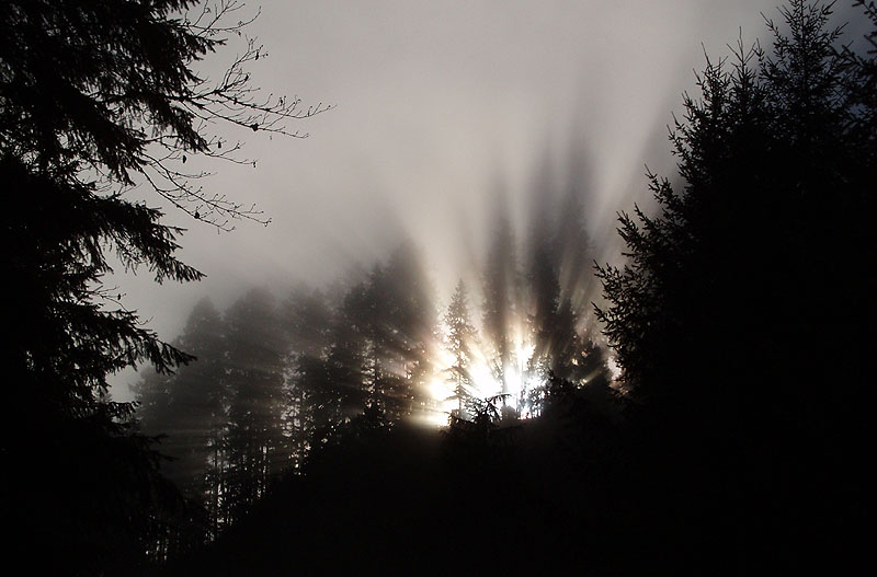
We stopped and enjoyed this spectacular mixture of sun, fog and trees during the shuttle for the lower five..
Recently we assembled a large group of paddlers to run the lower five. Most of the group hadn't done the run, so we planned to move relatively slowly and scout some of the bigger drops. We also planned to shoot some photos to help raise awareness about this section.
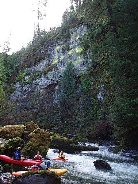
Nice scenery at the Black Creek put-in.
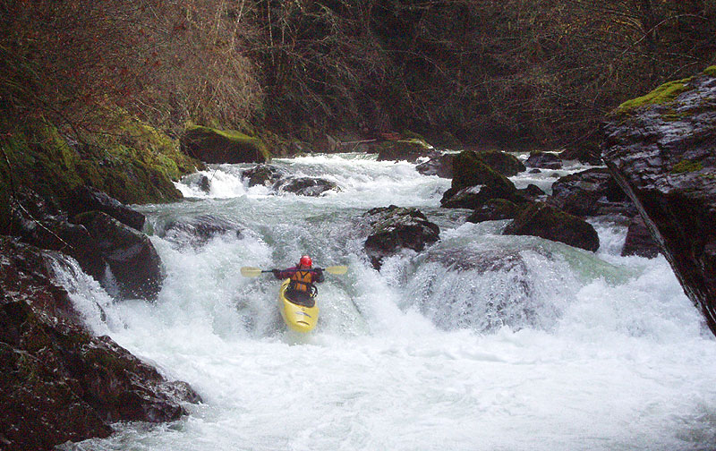
The first drop is immediately downstream of the put-in at Black Creek. Here the creek turns slightly to the left and drops out of sight. Just below is a fast, bouldery lead-in to a sweet sloping ledge. There are generous eddies above this drop on both sides, and a nice eddy on creek-left just above the final ledge. This drop is run down the right side, going with the flow over a perfectly placed auto-boof flake..
Megi Morishita runs the first significant drop, located just downstream of the put-in.
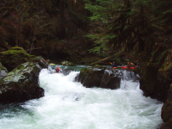
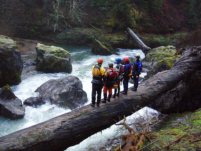
Just below the auto-boof ledge is a fun little bouldery runout, then some mellow floating. After about a quarter mile, keep an eye out for an obvious huge boulder on the left, which causes a sudden narrowing of the creek after a long straight stretch. This signals the beginning of Osprey, the most difficult rapid on the lower five. Be sure to eddy out high on the right, because once you pass the 'gates' at the top of Osprey you are committed to running the rapid.
The difficulty of Osprey varies significantly depending on flows. At two feet and up on the paddlers gauge ( ~400 cfs and up ) Osprey is more serious, with a powerful, retentive hole at the bottom. At lower flows ( ~250 cfs ) it is much more forgiving.
I have seen some strong paddlers swim out of the bottom hole at Osprey, especially at higher water. Be sure to study this one carefully, because it is more difficult than it looks.
The usual reaction after someone swims of the bottom hole at Osprey is: "I didn't expect x, y, and/or z to happen right above that last hole.."
Where x = "Those boils at the lip of the bottom hole slowed me down so much I couldn't get through the hole.."
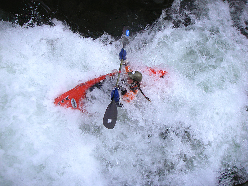
The final hole in Osprey is very retentive at medium to high water and will suck all the adrenaline out of anyone who ends up in it. The flow is backed up by a large boulder fifteen feet downstream, so if you end up in the hole there are few options except to smile for the camera and let er' buck!
It should also be noted that there is an undercut rock downstream of the final hole on the right side. This rock is is not easily seen while you are standing on the scouting log, and paddlers and gear often end up over there after a swim.
Scouting the moves through Osprey. This rapid is harder than it looks, especially at higher water.
Chris Gabrielli fires up Osprey..
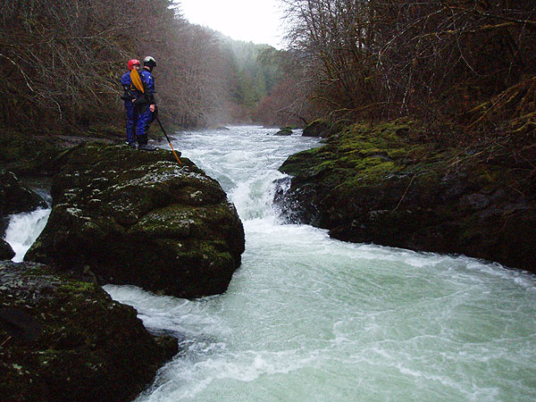
Scout or portage Osprey on the right. If you choose to portage, stay up a little higher, just above the scouting log, and work your way down the right side. This is also the side you set safety on, so those choosing not to run the drop are well positioned to support those who do.
Below Osprey the creek mellows considerably. The rapids are spaced much farther apart, and the creek is wider and generally less constricted. There are some smaller, fun drops interspersed with lots of mellow class two floating. The wider, sunnier nature of the canyon also means more alder trees and fewer large firs.
Grace Thompson runs a fun twisty ledge just downstream of Osprey.
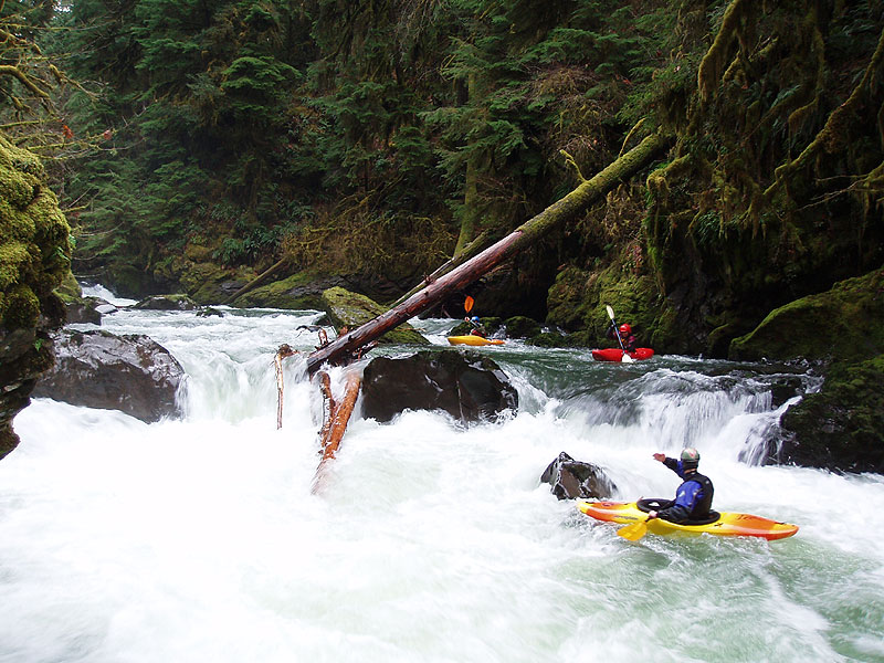
The next major rapid is a short ledge-like drop, which is much more forgiving than it looks. This rapid is generally run down the middle, with a delayed boof at the bottom. The hole looks retentive but all of the water is kicking hard downstream, so if you flip dig deep you will come out immediately.
It should be noted that this drop isn't actually a ledge. The hump in the middle of the drop is actually a narrow rock outcropping, so at lower flows the water starts to fall off into deep, foamy slots on either side of this rock. This one is definitely worth a scout on the left a low water, but at medium flows ( like those in this report ) it is very straightforward: just plug it.
Katie Wagner and Dave Porter watch as Chris Gabrielli runs the short-n-friendly ledge.
Katie Wagner digs in for the boof at the ledge.
Katie, same drop, from the side..
Downstream is more mellow floating, leading up to The Constrictor. This drop is pure evil and should only be run after:
1. Ingesting lots of holy water and garlic.
The only person I have ever seen run this drop was the utterly fearless and proportionately talented Dan-the-man Coyle, and he didn't make it. It took two of us to pull him out of that hole with a rope. I swear there were gremlins with grappling hooks lurking just below the surface, because they reeled Dan back up into the hole from six feet downstream. He was still in his boat when he came out though..
This drop is easy to see, the creek narrows abruptly after a long straight stretch. Eddy out on the right just above the drop and portage on the right side, or bang down the shallow right slot if the water is high enough.
Grace Thompson and James Bagley Jr. contemplate the horrors of the Constrictor.
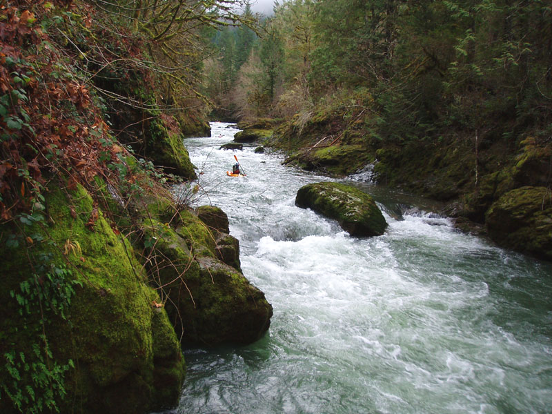
Downstream of the Constrictor is the final stretch leading up to the confluence with the South Santiam. As you float through this section the creek is gradually transformed into one of the most beautiful streams in the state. The deep green water rushes between vertical rock walls and massive old-growth firs with breathtaking effect.. take some time to look around in here, the scenery is extraordinary!
The rapids increase in quality along with the scenery on this lower stretch, with a superb series of clean ledges and fun little rapids. This final mile or two is the highlight of any trip down lower Canyon Creek.
Katie Wagner runs another ledge downstream, in the most scenic part of the canyon.
James Bagley Jr. directs traffic just downstream..
Just above the confluence with the South Santiam the creek opens up briefly, then closes in again as it descends through a final series of drops..
Jacob Selander cruises down the last mellow section above the bridge.
There is no direct internet gauge for Canyon Creek, but you can figure it out. Generally the actual flows in Canyon fall between Blue River at Tidbits the Wiley Creek internet gauges, weighted slightly towards Wiley, which is geographically closer. On this particular day we had about 375 cfs in Wiley Creek, and about 420 cfs in Blue River at Tidbits, which translated into ~400 cfs in Canyon Creek and two feet on the paddlers gauge under the take-out bridge. This is an optimal medium flow and a perfect first time flow for the lower five.
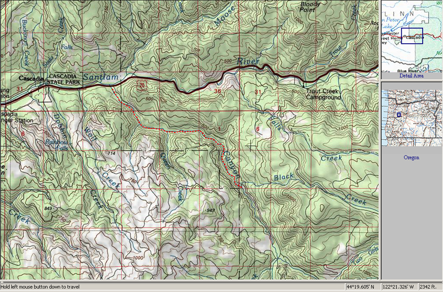
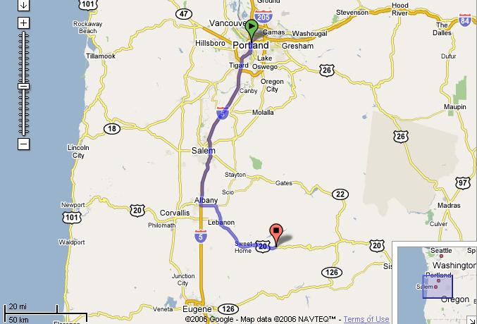
To reach the put-in, follow the directions to the put-in for Canyon Creek Oregon in Soggy Sneakers, but stop at the bridge over Black Creek, about 4.9 miles up the road. Hike down on the north side of the creek, there is a trail because this section is being run more often lately.
There are a couple of take-out options. You can take out on the right just before the bridge over Canyon Creek just above the confluence, doing a short climb up the bank to the road. Alternatively, you can continue downstream and float an additional mile through the Hobbit Gorge on the South Santiam to Cascadia Park. This gorge has little whitewater but possesses a rare beauty that is worth experiencing at least once. If you have cold weather, I recommend taking out at the bridge and leaving the Hobbit Gorge for another day.
The lower five, Black Creek to the South Santiam confluence.
According to Google Maps, the lower take-out at Cascadia is exactly two hours from downtown Portland, one hour and twenty minutes from Eugene, or an hour from Corvallis. The map below shows the driving route from Portland, the most distant population center.
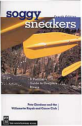
For more info on access and hundreds of other runs in the state, pick up the Bible for whitewater boating in Oregon and Southern Washington: Soggy Sneakers, the fourth edition.
or y = "I got pushed to the right just above the bottom hole, and I fell into it backwards/sideways.."
or z = "I got stuck in the second hole and swam the rest of it.. I got a high-five from Elvis before I went in the bottom hole.."
The bottom hole pictured here is very sticky, two people got the big momma smackdown in it on this particular day.
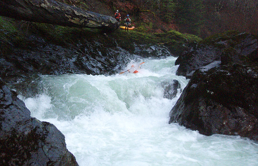
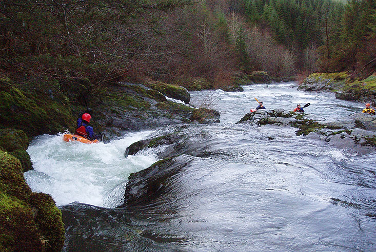
photo by Grace Thompson
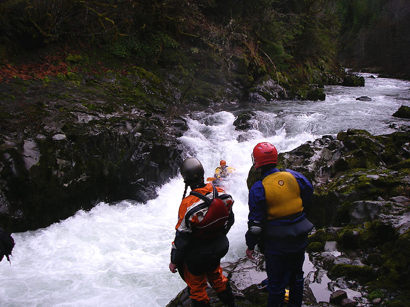
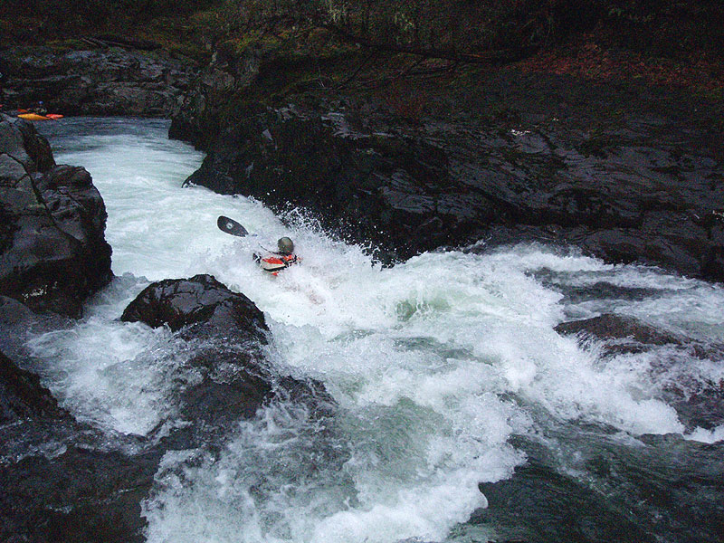
photo by Grace Thompson
2. Clipping a rope to the bow of your boat, with the other end of the rope in the hands of people who like you.
3. Positioning a harpoon gun above the hole in case the first two don't work, because you are never, ever coming out of that hole if you swim.
The far creek-left side of this drop is also runnable at medium flows.