The Salmonberry River and it's tributaries meander through sections of a 60,000 acre roadless area in the Tillamook State
Forest, located in Oregon's lush and rugged coastal range. Paddlers have been running the main stem of the Salmonberry for
years, but few have explored the headwaters of this wild and remote river. Personally, I find the more remote coast range
streams very intriguing; access is often difficult, and these streams are often spectacularly scenic.
Almost
without exception, you feel privileged to have visited these places at the end of the day.
As with most of the more remote coast range rivers, accessing the upper Salmonberry and it's tribs requires solving progressively more complex navigation problems. Most of the access roads that penetrate the mountains in this part of the state are unmarked gravel affairs that are often so tangled and convoluted that a good map and an unerring sense of direction are a necessity.
Even for the well-prepared shuttle epics are commonplace, and this day was no exception..
My friend Pete Giordano has spent a lot of time exploring the coast range, and in most seasons we reap the benefits of his hard work. As usual, Pete had the access all figured out, and we drove straight to the put-in with only two wrong turns. (this was pretty good, considering the dizzying array of roads we had to negotiate.. only those who have explored this area can truly appreciate this.)
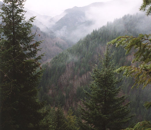
Looking down into the North Fork drainage, as viewed from the final road that descends into the canyon.
As usual we had a cunning plan, and as is often the case it proved to be not-so-cunning-what-hell-were-we-thinking in the
end.
Our plan seemed simple: To avoid the 45-minute, 35-mile one-way shuttle, we would use a shuttle driver. At the
end of the day we would rendevous at the bridge over the Salmonberry, and barring a vehicle breakdown, flat tire, general
confusion, misalignment of the moons, or alligator attack we would save 45 minutes!
Needless to say, we were feeling quite smug that morning as we watched the shuttle driver creep up the narrow road out of the canyon. After the truck disappeared, we shouldered our boats and began the descent to the river. After negotiating two hundred vertical feet of loose dirt and rocks we reached the river and were pleased to find an optimal medium flow, about 500 cfs.
On this particular debacle Pete and I were joined by the ever-optimistic Eric Johnson (EJ) and Eric Vermillion.
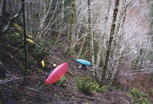
Eric Vermillion and Pete Giordano begin the descent to the North Fork Salmonberry
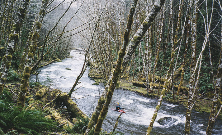
The North Fork is a classic coast range stream in terms of scenery, with lush, verdant vegetation typical of the more remote Northwest temperate rainforests.
Eric Johnson warms up below the put-in for the North Fork
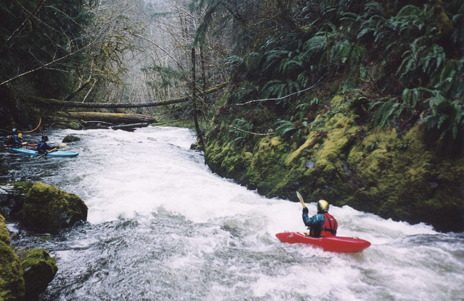
Once on the river we soaked up the scenery for the first quarter mile or so, but as the intensity of the rapids increased we spent less time looking around and more time peering downstream. Gradually the rapids grew into a series of fun and interesting ledges and blind boulder gardens. We only had to portage one small log in this section, which was a relief!
Eric cruises down a drop while Pete and EJ contemplate a blind corner from an eddy downstream.
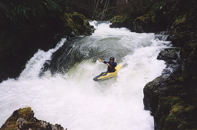
As we moved downstream the geology began to change and bedrock appeared. The ledges grew more distinct, and a small road appeared high on the left bank. From Pete's description we knew that there were a couple of larger falls downstream, and soon enough we arrived at the first.
Keep your bow up or get pounded.. the author boofs hard to avoid the hole on the second part of the double ledge-drop.
(Pete probed this one..)
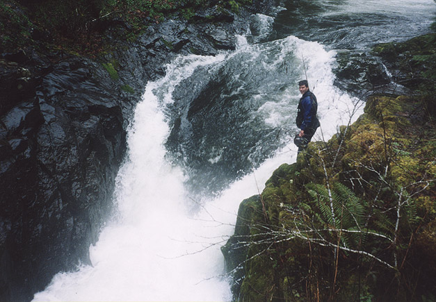
Below the double falls are a few more fun drops, then a significant horizon line. We got out on the left and scouted the final falls, which was V+ or VI, extremely dangerous, one of those drops that might not be survivable except at very low water. This drop reminded me of BZ Falls on Steriods, if that gives you any idea...
Ummmm... No.
Pete contemplates the hideous hydraulic and impressive undercuts at the base of North Fork Falls.
Once below the falls we were on the main stem of the Salmonberry. There were a couple of nice drops on the main stem (including a drop known as Chew-Chew) but we never got out of our boats, so I didn't get any photos. The main Salmonberry was much more mellow than the North Fork, but all in all I think that linking this section up with the North Fork is definitely a worthy trip!
Soon enough we got to the take out, and of course no one was there. Shit. No Shuttle. It was starting to rain, we were 35 miles from Pete's truck at the put-in, and it was starting to look like a very long day. Finally we flagged down a couple of fishermen and Pete and I hopped in the back of their truck. We chose well, because these guys were going back to Portland, so they gave us a ride all the way back to Salmonberry road, shaving 26 miles off of our trek.
Now we only had about 9 miles of gravel roads to navigate on foot, so Pete and I agreed that I would stay up at the road (in case the shuttle showed up, and besides, I don't think I could have found the truck anyway..) and he would jog back to his truck (in his drysuit and neoprene booties, no less!)
One hour and 45 minutes later I saw the shuttle truck coming down the highway loaded with boats, and they turned down Salmonberry to pick me up. It turns out the shuttle driver had missed the turn and had been driving non-stop the entire time, trying to find us! She had gone all the way out to the coast, then orbited down south and had come in the back way... Once I was in the truck we sped down Salmonberry road to try and catch Pete.
No dice. We were about a mile from the put-in when Pete comes screaming around the corner in his truck, windows down in spite of the rain, shirtless, looking a little crazed. "Geez.." I said to Eric. "He ran the whole nine miles!"
Sure enough, he had run the whole time, up and over the hills, and his feet where covered with huge blisters from running so far in the neoprene booties.. and his drysuit? Well, lets just say it has been condemned as toxic waste...
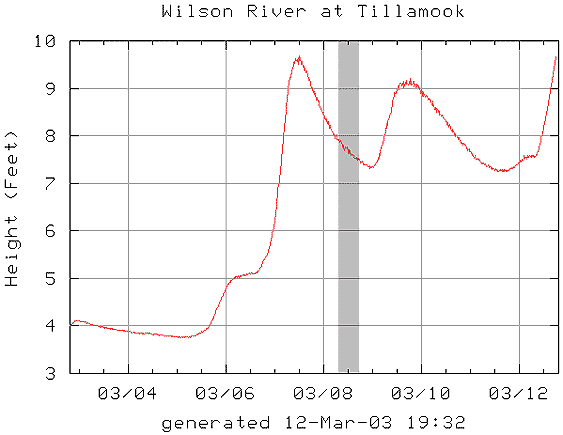
The Wilson River gauge seems to be the best internet correlation, with flows between 7-10 feet sufficient to paddle the Salmonberry drainage.