It seems like the Grays River has been on my 'to do' list for a long time now, but I just got around to it this year. In his description of the river Jeff Bennett says: "The Grays is one of those rivers you keep putting off, but once you do it you wonder why you waited so long.."
That pretty much sums up how I felt about this river; it has a cool gorge with fun drops that gradually build in magnitude before tapering off at the end. We ran the river with over a 1000 cfs in it, so we encountered stomping holes, pushy hydraulics, and high-quality rapids. That said, if you are a class IV-V boater living in Northern Oregon or Southern Washington and you haven't run this river, you are missing a real treat!
Pete Giordano, Marc Strabic and I headed up to run the Grays on November 18th 2001. The river is located about 1.5 hours north-west of Portland, so we got there pretty early. As we were running the shuttle we stopped at the top bridge and took a look down into the entrance of the gorge and checked the rapid under the bridge for wood. Everything looked good, so we headed up the road to the put-in. Pete had broken his Micro 240 in Salmon Canyon the weekend before, so he was back in the old Corsica long boat. Of course, Marc and I couldn't resist giving him a hard time about it. "Damn, Pete," I said as he unloaded it. "That boat is HUGE! You need a "LONG LOAD" sign and a pilot truck when you're transporting that monster?"
Of course, Pete would be getting the last laugh on this day. While Marc and I were barely making it through some of the holes on this river in our fat creekboats, he was slicing right through them in his longer, faster boat!
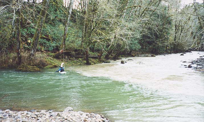
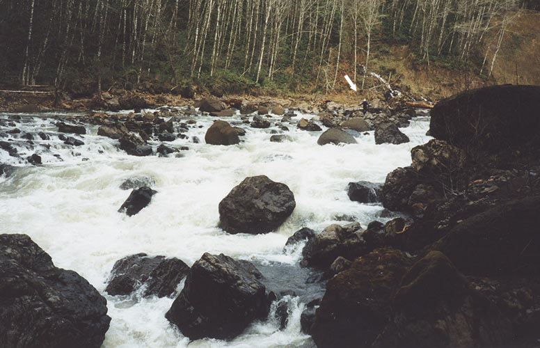
Just below where we put in the South Fork of the Grays comes in and discolors the main river. We suspect that the muddy water on the South Fork has been caused erosion from heavy logging somewhere upstream. It's really too bad, because otherwise the Grays would have relatively clear water at most flows.
Pete at the confluence with the muddy South Fork Grays just below the put-in.
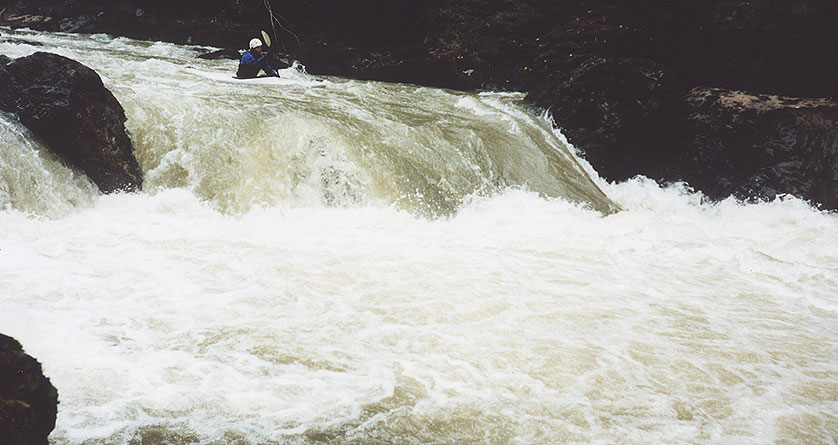
The first rapid of consequence is a stout class IV rapid that has swirly, pushy water leading to a uniform four foot riverwide ledge with a powerful hole. Just below this hole the river pounds down through a short, boulder choked drop that requires precise boat handling to keep from getting pinned against a large boulder that is blocking the flow on the right side.
We scouted this one and decided that the best line over the ledge was anywhere in the middle with speed. However, the backwash from the hole was cycling back in from eight feet downstream, so we had someone standing by with a rope as each person came down. The main problem here is that if someone got trashed in the ledge-hole and swam through the bottom drop, they could easily end up body-pinned against a boulder or the wood that was jammed in the middle slot. Pete ran first, going with the flow through the meat of the hole, and then the rest of us ran it with no problems.
Pete approaches the sticky middle ledge of the first sizeable rapid.
The drop just below this ledge contains several hazards
for swimmers.
I was kind of lagging behind in one of the larger pools, enjoying the scenery, but when I rounded the next corner I saw a large horizon line downstream. Pete and Marc were already out scouting, and Pete gave me the 'You're gonna want to look at this one' hand signal from the boulders overhead so I got out to scout it. "Wow!" I heard Pete say as he started climbing over the boulders above the horizon line, which always means it is going to be GOOD!
I scrambled up on the rock wall overlooking the rapid (which the guidebook
refers to as 'SuperBowl') and it looked
really good. Below us the river dropped over a series of short, powerful offset ledges before dropping down into a big ol' stompin' hole at the bottom. "I think you run it right down the gut." I said. "You boof off the top ledge driving to the left onto the main tongue and by the time you hit that bottom hole you'll be goin' about 50 miles an hour;
dive under it,
pop up downstream,
no problem!"
There was no way to set up safety for this drop because the rock walls
were too vertical, but there was a pretty big pool above what looked like
a very large rapid downstream, so no worries if the probe got a beating,
we decided.
I decided to go first so I headed back up to my boat. I got in and pulled
out into the current, driving left to stay in the main flow. I got a good
boof off the top ledge, but as I dropped down into the tongue the hole
looked a helluva lot bigger that it had when we were standing 30 feet
overhead! I put my head down and starting paddling for all I was worth as
I dropped dead center into the middle of the hole... I went deep but
suddenly I realized I wasn't going downstream anymore! I surfaced in the
recycle and started getting pounded! I threw three fast cartwheels in my
Gradient, the kind of totally out-of-control cartwheels that often signal
the
beginning of a good thrashing! Fortunately on my third cartwheel I got a good hard stroke in and I shot out in a huge backender with enough force to push me downstream, where I rolled up with a yell!
Now, it never does much for your confidence to watch your buddy throw ends in a hole you are about to drop into, but Marc and Pete shrugged it off and headed back up to their boats. After all, I had flushed out, right? Marc went first and after watching me get stopped by the hole he was really charging! He totally disappeared into the hole for a one count, popping up just on the edge of the boil line. "Uh oh." I thought as the hole started pulling him back upstream, but he quickly rolled up and paddled out, no problem!
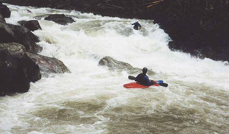
Pete came down next and in his long boat plowed right through the hole as well.. This was one sweet drop!
Pete gets ready to drop into the beefy hole at 'Superbowl' while Marc looks on.
Just downstream from Superbowl the streambed started getting choked up with boulders as we approached a large horizon line. We could hear a loud rumble downstream, and we all knew we had arrived at the big one.
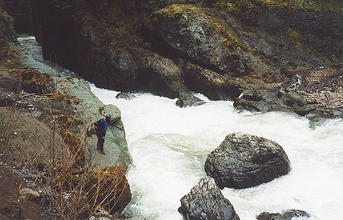
Marc and I got out on the left and scrambled downstream while Pete got out on the shoal on the right side of the river. This had to be the rapid known as 'Picnic', and it was definitely class five at this flow.
Picnic starts with a long, technically demanding boulder slalom that ends where the river funnels down between vertical gorge walls with some very large hydraulics. The top part has several boulders that have pinning potential on the left, forcing a run down the right, with a mandatory move to the left at the bottom to avoid some nasty looking slots against the right wall at the bottom and the large hole in the middle.
Pete (indicated by the arrow), scouting the top half of 'Picnic' from the island/shoal in the middle of the river. The main hazard in this top part is the round, undercut pin rock in the middle of the photo. We went just to the right of this rock and then moved back to the middle once past it.
Marc scouts the bottom half of 'Picnic'.
Below Picnic the river drops through a nice gorge and then turns abruptly to the right at the last large rapid, known as 'Broken Paddle.'
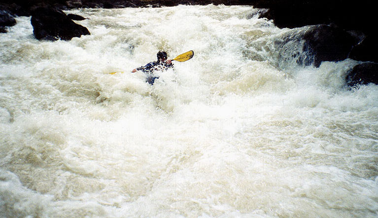
This drop is not nearly as big as Superbowl or Picnic, and when I got out to scout I blew it off. "No problem." I said. "Big hole in the middle, go with the flow and you'll go right through it."
"Man, that hole looks like a keeper to me." Marc said. "I'll give you a
rope.." I headed back up to my boat and peeled out into the current and
drifted downstream. I angled right and took a few strong strokes but the
water funnelled me down right into the meat of the hole, where I
disappeared for what felt like forever. (Pete later said I was underwater
for a two count after I disappeared into the hole..)
I surfaced upside
down and
I could hear the roar of the hole and I thought: "Oh shit, I'm still in
it!!"
I didn't even bother trying to roll, I just started reaching and digging as deep as I could, trying to grab any of the green water going downstream with my paddle. After about 10 to 15 seconds the roar of the water lessened and I snapped off a quick roll. When I came up all I could hear was Pete yelling: "Go!! Go!! GOOOOO!!" and I started paddling with a vengeance to get out of the recycle! Pete told me later that I had never actually been in the hole itself, but that I had surfaced on the edge of the boil line and was held there by the powerful cross currents until I rolled..
That was enough for Pete and Marc.. They shouldered their boats and walked this drop which was probably a good idea; we later read Jeff Bennett's description of this run and he warns paddlers about this hole!
The author going for the gut at Broken Paddle. (Photo by Pete Giordano)
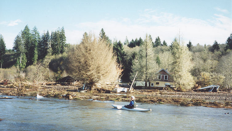
Pete checks out the wreckage of a house on the lower Grays.
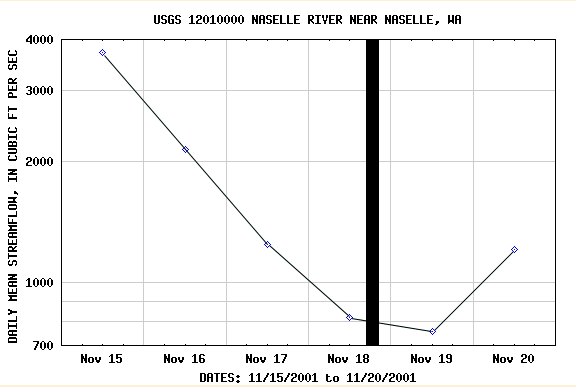
FLOWS: The Naselle internet gauge provides the best correlation for the Grays. You can run this section at 550 and dropping, but a more fun flow is 800 and stable or 700 and rising slowly.
The graph shown below shows the flows on the Nasalle Gauge (800 cfs and stable) the day the photos on this trip report were taken. This was an optimal medium flow for the Grays. (the black vertical bar shows when we were on the river).