
This time down we were joined by prolific first descentionist Dan Coyle, who was lured to Stebbins by our marginally believable tales of big drops in a remote canyon. He enjoyed the creek and of course managed to bag yet another first descent on the way to the creek. The trail to the put in closely parallels the South Fork of Stebbins Creek, and about halfway down the ridge Dan left the trail and bushwhacked down the steep bank to do the first descent of the South Fork. John and I continued on down to the confluence and shortly after we arrived Dan paddled into view and reported two more twelve foot falls on the South Fork. (He ran both).
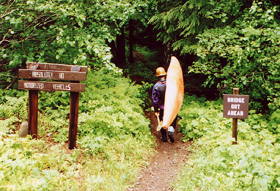
Dan begins the hike down to the put in on Stebbins Creek.
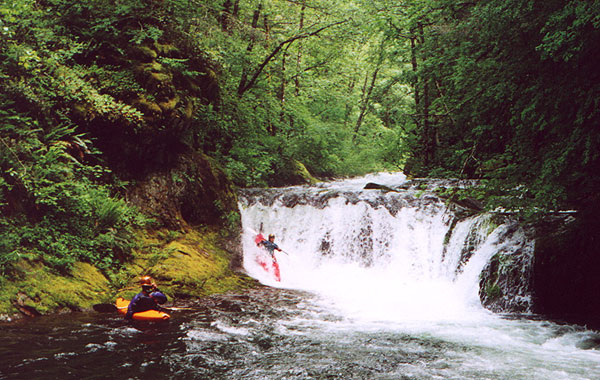
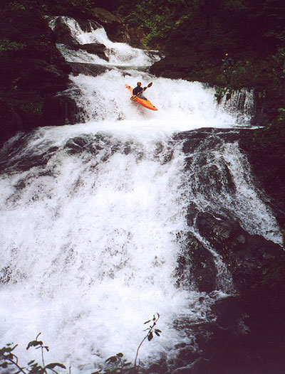
Below the confluence of the North and South Fork the creek tumbles right along with some nice class II-III warm up rapids until the first horizon line which marks the first falls and the beginning of the steep section. The fun starts with a ten foot falls that drops immediately into a hundred foot long bedrock slide that ends abruptly at a twelve foot U-shaped drop known as Jetboat Falls. I scouted quickly and confirmed that Jetboat was clean and we all shot over the far right side.
John runs Jetboat Falls.
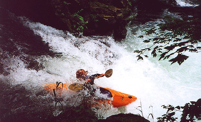
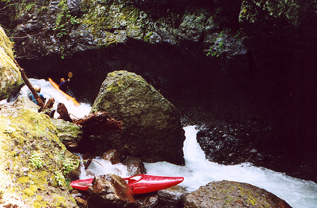
Downstream from Jetboat the creek mellows out and there are some smaller boulder gardens and then the creek narrows abruptly and tears down a chute and over a cool ledge drop known as 'Get in my Belly'. This narrow eight foot sloping ledge pours into a small twenty foot diameter punchbowl with an exit on the left side. The rock formations around this drop are really interesting but you need to pay attention when you run this drop! I got out to scout and gave Dan and John the signal that the drop was clear and they both blasted down with no problems, angling to the left and out of the punchbowl. By the time I hiked back upstream and ran the drop Dan was already downstream and John waited by the exit of the punchbowl to make sure I ran the ledge without problems. When I came down I angled right into the punchbowl and got against the right wall. John saw that I was ok so he peeled out and dropped out of sight around the corner, but I wasn't out of there yet! On the right side of the bowl the current swirls around and feeds very strongly back into the hole at the base of the ledge, and I had a bit of a hard time getting out of there.. Finally after a few well placed prys against the right wall I got out into the downstream current.
Dan runs Get in my Belly.
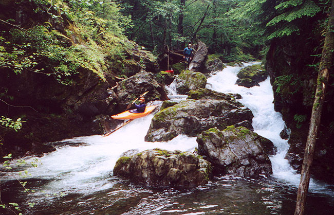
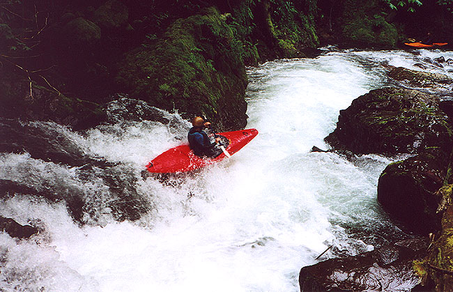
Below the ledge is a steep boulder garden. The entrance is tricky here and the left side feeds into a mean slot, so be sure you go right at the bottom! There was a log pinned in the right chute and Dan managed to run this drop with style, sliding down the log at the bottom just for fun...
Dan slides down the log at the bottom of the boulder garden while John watches from upstream.
Just below this drop is Lethal Injection, a severely hazardous waterfall that contains a deadly sieve. John and I ran this falls on the first descent at very low flows and deemed it to be very dangerous at the time. This one only get worse with more water, and it was solid class six at this flow. Paddlers must take out on the left above the falls and shimmy down an old growth log that forms a bridge over the falls to portage this one. The portage is not difficult, but the most tricky part is the scramble up out of the pool above the falls onto the roots of the bridge tree. (Photos of our low water run over Lethal can be found on the first descent trip report on the site.)
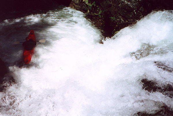
Just downstream is the biggest drop on Stebbins Creek, the awe-inspiring Tsunami Falls. This fifty foot, four tiered waterfall is mind bogglingly exhilarating to run and is one of the most spectacular drops I have seen anywhere. At this much higher flow Tsunami would be extremely difficult to portage, so come prepared to run it. (I had a hard time clambering downstream to take pictures and I couldn't imagine trying to do it with a boat!) The first falls on Tsunami still has a log vertically pinned in it, so we were all very careful here. Everyone managed to boof hard to the left, and though I hit the log about three times on the way over the first falls I managed a clean line over the rest of them. John boofed way too hard at the third tier and cleared the punchbowl where he pitoned into the rock on the far side, bending the bow of his Overflow!
Dan runs the third tier of Tsunami Falls.
Below Tsunami is another fun, steep boulder garden and then the creek disappears abruptly into the Zoom Tube. Here the creek tears around a right corner under a fascinating overhanging wall which greatly amplifies the sound of the water. This extremely tight triple drop has only been run twice and is quite difficult with severe pinning potential in the first and second drop. On the first descent I ran this rapid against my better judgement and got worked pretty good against the left wall, so I joined John in the portage over the boulders on the right side of the creek. Dan chose to run this rapid and judging by the look on his face when he emerged he too got well acquainted with the wall on the way down...
Dan runs the first drop in the Zoom Tube.
One of the last major drops is Bongo Fury, a twisty ledge that drops into a narrow, violent chute. This drop looks innocent from above but is quite difficult and can be very painful if you miss your line! Paddlers running this drop must boof hard to the left in order to avoid the wickedly jagged boulder on the right side of the chute- if you miss the boof it's going to hurt! On the first descent I got worked hard against the boulder, and though most of the boulder was covered at this flow there were still a few jagged edges sticking out waiting to penalize the unlucky paddler. Fortunately we all nailed the boof and then continued downstream through the last quarter mile of mellow class II.
John nails the boof at Bongo Fury. You can just see one of the jagged points on the boulder sticking out to his immediate right. That thing is pure evil- I swear it attracts elbows like a magnet!
The last major drop is Mad Dog Falls and is visible from the bridge. Mad Dog is a twisty twelve footer with most of the water funneling to the right. At this flow there are a variety of lines from left to right, with the right side dropping into a soft, deep, hydraulic- if you run that side get ready to go deep! (Only Dan ran the right side on this trip.)
John below Mad Dog Falls.
Access and Flows:
Stebbins has a tiny drainage so it only runs after a few days of rain in the spring or early summer and all during the rainy season. To determine if there is enough water in the creek, look downstream from the put in bridge on the right side of the channel; the rocks in the channel on this side should be covered. If they aren't try to imagine boating over them because that is what some of the shoals are going to look like.
To get to the take out, follow the directions in the guides to Doc's Drop on the waterfall run on the Washougal River in Washington. Just downstream from Docs is a bridge over Stebbins where you get a very nice view of Mad Dog Falls. This is the take out. To get to the put in, head up the gravel road (known as W2000) about 1.8 miles above Docs Drop stay right and about 2.3 miles later you come to the top of Deer Creek divide. Once you cross the first wooden bridge across Deer Creek turn right and drive about 2.25 miles to a four way intersection. Turn right again here (following the signs to Beacon Rock and road 1440) about 2.5 miles later just before milepost 12 the road crosses the diminutive North Fork of Stebbin Creek. On the far side of the creek on the right hand side of the road follow the signs pictured at the beginning of this trip report down to the confluence, which is about a two mile mostly downhill hike on a good trail.