The East Fork of Rock Creek
AKA 'The Rock'

An account of the first, second and third known descents of The East Fork of Rock Creek.
James Bagley Jr, Jason Rackley, Jon Fowlkes, Mike Long, Pete Giordano

Location: Oregon, North Santiam drainage
Class: V
Gradient: 410 fpm on the East Fork, continuous
Length: 1.5 miles on the East Fork at 410 fpm, 1.3 miles on the main stem at 200 fpm
Nature: Exploratory
Character: Extremely continuous steep creek with numerous ledges, falls and boulder gardens. Body armor highly recommended.

Torture Factor: Medium


Copyright © 2007, Oregon Kayaking. No part of this page may be reproduced, linked, or copied without the express written permission of the Oregon Kayaking webmaster.

The East Fork of Rock Creek ( aka The Rock Creek or simply 'The Rock' ) is a full-on, bare-knuckled brawler and one of my personal favorites. This creek has an outlandish gradient created by a non-stop series of ledges, falls and boulder gardens that thunder down through Rock Creek Canyon.

Paddlers who attempt this creek need to get an early start and be wary of wood that is constantly shifting in the creek bed ( as of 2/16/07 the East Fork log situation has improved dramatically and there are no log portages, but this could change at any time ).


Looking down into the East Fork of Rock Creek.
Photo by Pete Giordano


The story of how we discovered this little gem is worth telling.
On February 4, 2006 and Mike Long, Pete Giordano and myself set out to run Upper Silver Creek near Silverton. It had rained pretty hard the day before and we were hopeful there would be enough water. When we arrived at the put in for Upper Silver, there was a decent flow but not the healthy flow we prefer, so we decided not to run it.

Pete had been checking out Rock Creek, which is a tributary of the North Santiam river. We knew that Gabe Flock and Dan Coyle had run the lower sections back in the nineties, but we had no info on the upper reaches.

After poring over the maps, we decided that we would try and hike down to the confluence of the East and West forks of Rock creek, because we assumed that neither of the two forks would be big enough to run.

We wandered around in the hills above Mill City for probably an hour before we finally found the bridge over the East Fork, which looked small and uninteresting as expected. We continued downstream and had driven a couple hundred yards up the ridge when Mike yelled "STOP STOP!!!".

Mike had been staring down into the forest, trying to see the creek, and had caught a glimpse of something that looked like a big falls. We scrambled down through the forest and beheld a beautiful, completely runnable plunge falls. We were elated and decided to put on right there. To see what happened after that, you can watch this film I made of our low water first known descent.

james bagley jr. probes Nutcracker Falls
on the second known descent

photo by Mike Long


Shortly before the flood in November 2006, we assembled a strong team and returned to the Rock with the intention of running every rapid on the creek ( we had portaged a few the first time down ). We arrived at the put in bridge and were pleased to see a reasonable amount of water, more than we had the first time but not too high.

This is as mellow as it gets. Looking downstream from the put-in bridge for the Rock.

We put on the creek and bounced down the first quarter mile or so above Nutcracker falls. Thankfully there were no logs to portage on this section, which had never been paddled prior that day as far as we know. We found a couple of nice smaller drops, but nothing like the big ones below the falls.

Jon Fowlkes runs the first drop, just below the put-in bridge ( this is the horizon line visible in the photo above ).

Jon runs another fun drop downstream.


After a few minutes we arrived at Nutcracker Falls, a technical thirty foot falls that plunges into a deep pool. Mike Long bagged the first known descent of this drop on our initial run, and with more water it looked even better than before.

There are some logs floating in the pool on creek-left that look pretty bad from above, but after probing the pool near the logs I determined that the water over there was only about five feet deep. This mitigated our concerns about a swimmer getting stuck under the logs, which lowered the tension level somewhat.

Pete and I decided not to run this drop, and we portaged on opposite sides of the creek. The creek-left side has a steep animal trail leading down to the pool, while the creek-right side portage leads to a weakness in the gorge wall where some local fishermen have fixed a sketchy old rope. Either side is fine for solo portaging, though the creek left side is probably better for safety and media.

Jon Fowlkes and Mike Long scout Nutcracker Falls.

After contemplating the tricky lead-in ( the falls careens off the right wall at the lip before dropping into the pool ) James Bagley Jr. decided to probe it. We set up safety on both sides of the pool and James fired it off, landing perfectly in the middle of the pile. Nice!

Jon Fowlkes followed shortly thereafter, then Mike, all with perfect lines..

Jon Fowlkes runs Nutcracker Falls.
Mike Long runs Nutcracker Falls.


Below Nutcracker were some more smaller drops leading up to a large horizon line that marks the first drop in Sluice Box. Pete Giordano probed this drop on the first known and named it after the narrow, chaotic chute that leads up to the small, churning pool at the bottom of the drop.

We scouted this one briefly, then ran it cleanly. Be sure to stay somewhat middle on the second ledge, the far left side has shallow spots. In my opinion, Sluice is probably the best single rapid on the East Fork.

Jon Fowlkes and Mike Long scope out Sluice Box, a long series of falls and slides stacked up all in a row.

James Bagley Jr. runs the first drop in Sluice Box.

James Bagley Jr. runs the second drop in Sluice Box.
This ten-footer requires precise boat handling because of the log on the right and shallow spots on the left.

James Bagley Jr. finishes off Sluice Box.
photo by Mike Long


Below Sluice Box the creek continues to careen downstream over small boulder gardens and ledges. Eddies are hard to find, but luckily there wasn't any wood to be seen. After some steep drops, the creek bent to the left and I saw a moss-covered rock wall on the right.

I remembered this wall from our previous trip and I scrambled into the conveniently-located eddy on the left side. Just below this last-chance eddy the creek took an abrupt turn to the right and dropped out of sight over a big horizon line, marking the entrance to 'Damage Incorporated'.

Once we were all safely in the eddy, we scrambled downstream on the left to scout. Damage had never been run up to this point as far as we knew, so we studied it carefully. One concern was the depth of the bottom pourover, so I jumped out on a boulder with a stick and checked the depth. Sure enough, there was a rock about eighteen inches below the foam pile but we decided it wasn't much of a hazard so long as you weren't upside down.

Of course, getting through the middle of this drop hairy side up didn't look easy. The first drop plunges into a narrow pool with a sticky hole backed up by a boulder. From here the creek plunges down against the right wall into a hideous-looking mess of rocks and logs, then weaves left, then drops over the final big pourover with the rock in the landing.

Finally Pete decided to make the first known descent of this nasty looking beast. Everyone spread out along the drop with ropes for safety and Pete came down. He ran the first drop and it stopped him cold and pushed him against the right wall. He managed to claw his way out of the hole and then came crashing down the middle of the drop, made it through that part ok then dropped the final pourover without a problem!

We were all whooping and hollering with his clean run, and once he was clear we all went back upstream and fired er' up. This isn't my favorite drop on the creek, but you take the good with the bad..

Mike Long fires up Damage Incorporated. Only two-thirds of this drop is visible in the photo, there is more downstream.
This drop is very technical, but we all had clean lines. Pete Giordano made the first known descent of Damage shortly before this photo was taken.


Immediately below Damage is Ghost Rider. Catch the first eddy on the left below Damage and scout. Ghost Rider drops sharply to the right and should be scouted for wood. The eddy on creek-right immediately below this drop is where you have to be if you want to scout Ghost Rider, which is the next blind drop visible downstream.

Ghost Rider is named for the log that runs the length of the rapid. Depending on the current configuration and flows, this log can either help or hinder your line over this drop. Scout on creek-right and take note of the piton rock on creek left, it has caused some painful collisions in the past. End-to-end pins are also possible here if you aren't careful. If you decide to portage, stay close to the creek and scramble under the logs on creek-right in the dry channel.

Pete Giordano runs the lead-in to Ghost Rider.
If you miss the eddy on creek-right where Jon is sitting you get to run Ghost Rider blind, which would be bad..

Jon Fowlkes runs Ghost Rider. This drop requires either precise boat handling or very good elbow pads.
Note the 'ghost' log pinned vertically in the middle of the drop and the piton rock on creek-left, undercut on creek-right, etc, etc..

Downstream of Ghost Rider there are more ledges, but be on the lookout for 'The Nam' flatter hundred-yard section that is notorious for collecting wood. The Nam starts as the creek widens and bends around a gradual right corner and piles into a large root wad in the middle of the creek. The far left channel against the wall was clear on our second descent, but be careful. Below the root wad is a small pool, then a few more logs over the next hundred feet or so.

We portaged this whole section on the first known descent ( see the video, this was horrendous log portage #1 ) but you could paddle through all of it on the second descent. The configuration of wood in this section could change at any time, so approach this section cautiously. Probably the best bet would be to send someone down to eddy out on the right at the root wad. If you climb up on top of the wad you can see the whole section and determine if you should portage or not.

Downstream of the Nam the rapids pick up again, with more ledges leading up to Crescendo, the final big series of drops before the confluence. Run the lead in ledges, and get out and scout on the right hand side when you reach the first big ledge.


At Crescendo the creek drops into a mini gorge which contains three drops in a row. The first is a ten foot ledge that has two logs crossed in the landing. This is followed by a chaotic chute, which leads into a sweet narrow ten foot drop into a deep green pool. Be sure to scout the final drop before committing to the gorge, because it tends to gather wood.

James Bagley Jr. relaxes below the entrance to Crescendo.
This ten-foot ledge requires a precise line, dropping between the two criss-crossing logs.

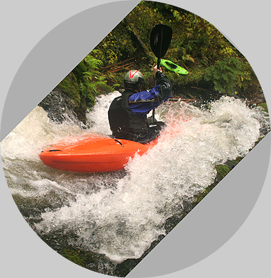
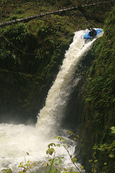
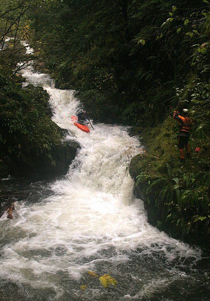
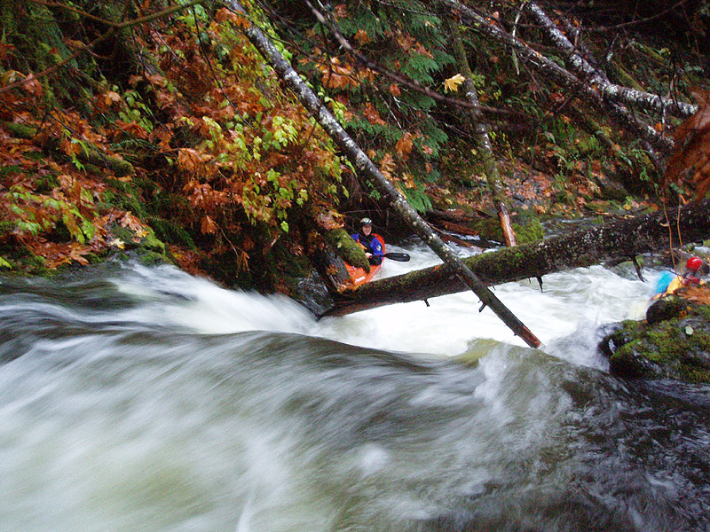
James Bagley Jr. gets ready to seal launch after shooting video of us running Crescendo.
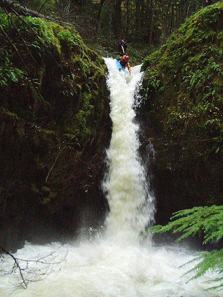
The last of three drops making up Crescendo is pictured here.

Below Crescendo is Last Caress, a very fun slide that empties into main Rock Creek. Here the flow doubles and becomes Rock Creek ( Pete and I have scouted the west fork, which has tons of wood and trashy drops ).

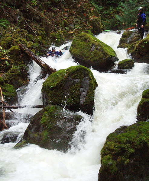
The main stem of Rock Creek is mellow for awhile, with some small ledges in the five to six foot range which are boat scoutable at medium to low flows but might develop some big holes at higher water.

The first scout-worthy drop is Piledriver, which comes about a mile downstream. At Piledriver the creek flows between vertical walls and turns sharply to the left. This drop is scoutable and/or portagable on the right hand side. It is also possible to set safety on the right. Piledriver is a double drop with some funky hydraulics and a sticky hole at the bottom.

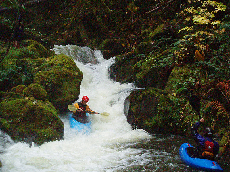
Below Piledriver, the creek mellows and widens. The action picks up again below a huge old growth log that blocks the creek, visible on a straight stretch. Portage on the left, pretty easy walking. Below this huge log ( that fell in during the massive '06 flood ) the creekbed solidifies and accelerates over some bedrock slides as it turns to the left. Run this section and then eddy out right as you go around the blind corner to the right. This rapid used to be known as 'Do or Die' because the final drop here ( where the huge log is teetering on the midstream boulder ) was choked with wood. It is now free of wood on both sides, but it worthy of a quick look. Also scout the log situation just downstream while you are scouting this final drop.

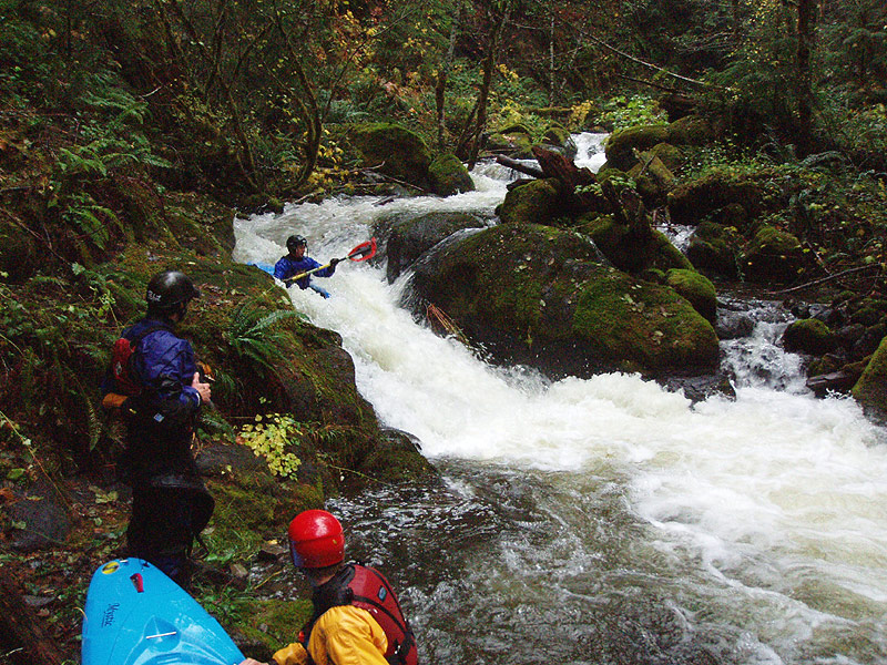
Downstream of Do or Die is a logjam that was blown out in the ten year flood of 2006. Scout this one on the left hand side, it is now runnable but worth a peek for wood. Once below this final jam there is one more large rapid, known as right-right-right. This large boulder garden has three distinct drops, and is run ( you guessed it ) on the right all the way down.

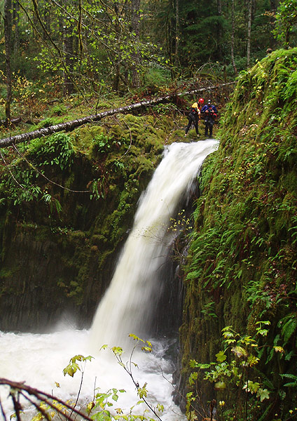
Immediately below Right-right-right is the take out. Eddy out on the left side of the creek and hike up the short trail to the road ( the trail is easy to find, catch the first eddy on the left after the log portage upstream of Jumbleia and you will see the trail ). Just downstream is Jumbleia Falls, a monstrous mess of logs and wood which is nice to look at but not to run. Below Jumbleia is a short gorge with more wood and then a bridge over the creek. It is recommended that you take out above Jumbleia, and save yourself a lot of portaging in the final gorge.


POST-FLOOD UPDATE: After the massive ten-year flood in November 2006 I was a little worried about this creek. In February 2007 we finally had a nice rainstorm so I soloed The Rock to check for wood and other flood damage. This was the third known descent, and I recorded what I found in my 'other adventures' blog.

FLOWS: Amazingly enough, the main fork of Rock Creek has an has an internet gauge located on the USGS site. Unlike Sardine Creek, this run doesn't need a flood event to get going. However, Rock Creek only drains 15 square miles, so storms that move through the area need to score a direct hit in order for the creek to run.

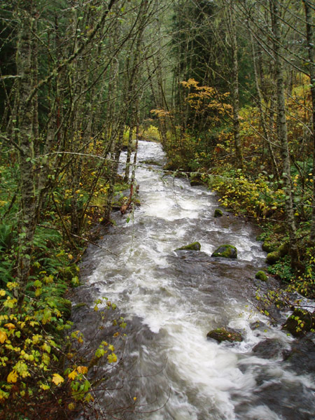
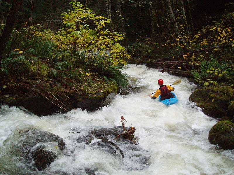
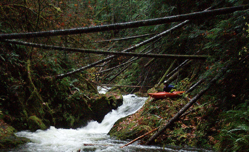
Visually determining flows: The basic rule is that when you arrive at the put-in bridge, the view downstream should resemble the photo at the beginning of this trip report, i.e. there shouldn't be any rocks visible in the middle of the creekbed but you should be able to eddy out on the edges of the channel. If it looks like you are going to be hitting lots of rocks ( too low ) or there are no eddies to be seen ( too high ), I recommend going elsewhere.

The East Fork is a tributary of a the main Rock Creek, so it runs off very quickly after a storm, esp if the rain stops completely. See below for my observed flow dropoff after a big storm. The orange line indicates the actual rate of flow drop of the East Fork vs. the main fork, which is the internet graph. Since 400 cfs is the minimum flow you need on the actual gauge, then you need to take this orange line into consideration, esp. if it has stopped raining and the creek is falling. If this is the case, then 600-700 cfs is actually the minimum flow as indicated by the relationship between the orange bar ( actual flow in the east fork, observed ) and the main creek. In the case of the graph below, the creek was runnable both February 15th and 16th, but not before or after that.

The shaded green area indicates a runnable flow window. The orange line represents the actual flows in EF Rock Creek after rain stops falling in the drainage. 400 cfs on the main gauge is the minimum runnable flow for the EF Rock Creek, but how you arrive at the actual flow depends on whether the creek is falling, rising, or steady.

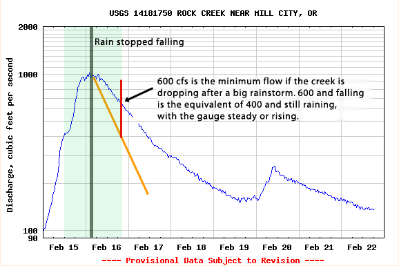
If it is still raining and flows are stable or bouncing around, you can use the actual blue bar on the flow graph. In this case, 400 cfs actual on the flow gauge would be the minimum flow.

An upper flow limit for this run has not yet been established, but it regularly gets up to 2,000-3,000 cfs during big floods. I'm thinking it would get a little hectic at those flows.

The put-in for this run is only about seven miles southeast of Mill City, so checking weather and radar for Mill City should give you a good idea what is going on in the drainage. You can also check the gauge visually, it is located approximately 3.3 miles upstream of the North Santiam on the right back ( just above the first bridge you reach over Rock Creek on the shuttle - the bridge you do not cross - at GPS N 44° 42'44", W 122° 25'35" ).


ACCESS: Access is somewhat complicated even though there are roads the whole way. The take out is pretty easy to find because there are landmarks. The put in is somewhat more complicated, but not too bad. The main thing to remember about driving to the put-in is not to turn too early. There are a couple of dead-end roads that go off to the right down into the canyon ( we took all of these on the first known ) but only one goes all the way to the creek.

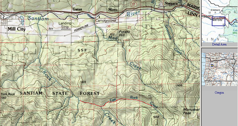
First, a zoomed-out map, with the run highlighted in red on the bottom-right.
It is only six miles from the bridge over the North Santiam in Mill City to the put-in for this creek.

To reach the take-out: Drive to Mill City and cross the North Santiam.
Take the first left after crossing the North Santiam and drive 0.4 miles until the road ends with a T intersection.
Turn left at the T intersection onto Kingwood Road.
After 1.7 miles you will cross Rock Creek, keep going a total of 2.2 miles until you reach Rock Creek road on the right ( a half mile after you cross Rock Creek ).
Turn right on Rock Creek road. Drive 0.5 miles up Rock Creek road until the road bends sharply to the left, stay straight here on a narrow paved road that goes uphill.
After a couple hundred feet turn right by a house on the side of the hill ( if you stay straight you go to the put-in ).
The road turns to gravel as you drive up along the main stem of Rock Creek, which will be visible on your right.
After 1.16 miles you will reach a bridge across the creek. Do not cross the creek, stay left.
After another mile or so you will cross the creek and the road will climb up a steep hill.
You will pass a road on the right side, and then a small creek flowing down the hill on the right side. You will top out, then pass another road going off to the right. From this second road it is .2 miles to the put-in trail. The road will bend to the left and then start going uphill again. When this happens, look on the left side for an old dirt road on this second uphill pitch. This is the put-in trail. If you get to where the road forks you have gone too far.

The old dirt road goes downhill and becomes a trail after about fifty feet, coming in about fifty yards upstream of Jumbleia Falls. The trail is wide and well used, mostly by fishermen and locals who swim in the creek in the summertime. It is about a hundred yards downhill from the road to the creek. It is wise to scout the take out, because it is easy to miss if you don't know where it is. Taking out at Jumbleia Falls is awful, don't try it! The trail is much better.

To reach the put-in: The put in is located at GPS N 44° 42'112" by W 122° 21'765".
Drive 3.26 miles back to the original intersection by the house, and turn right ( going uphill ).
0.36 miles after you turn there will be some roads branching off, stay straight on the main road.
After 0.81 total miles from the house intersection the road will start to go uphill steeply through some switchbacks, this is a good landmark.
After 2.12 total miles there will be a road off to the left, stay straight ( right ).
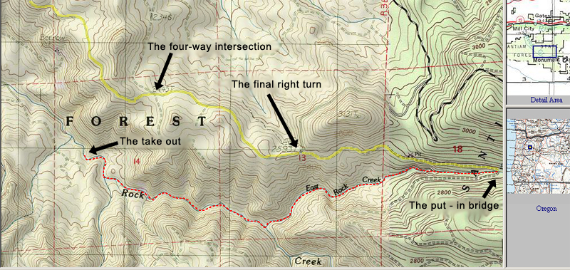
After 3.38 total miles there is a four way intersection shown on the map below, stay straight here on the main road.
After 4.43 total miles is the key turn shown on the map below, the main road veers left and a less used road bears off to the right ( downhill ) off of the main road.
Turn right here onto the less used road, which will rapidly descend into the East Fork Canyon less than a mile after you turn. After 5.65 total miles you will reach the bridge over the East Fork, which is the put-in.

A zoomed-in map, showing the put in bridge and the take out trail. The shuttle road to the put-in is highlighted in yellow.