By Steve Stuckmeyer. Trip date: April 11th, 2000.
Editors Note: Paddlers are now using an alternate access point to avoid the endless portaging described in this report. See the end of this report for details.
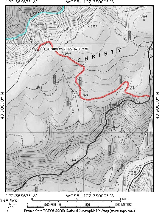
Christy Creek. First run in 1993. Seven miles long. Average gradient 300 fpm, with one half-mile at 600 fpm. Located 600 feet down in a mostly inaccessible and heavily clear-cut gorge. Class V+.
If you are an experienced creek boater, you probably have already imagined much of what I'm going to tell you. A word of warning: this narrative is in no way meant to encourage running this creek and my routes (or memory thereof) may be incorrect or unsafe. I imagine my tale of hardships will keep most folks off this creek; if it only whets your appetite, then I can only wish you luck and a safe journey.
As early as a year ago I had started to seriously wonder what mysteries Christy Creek held, and it's hard not to. Just above Christy's confluence with the North Fork of the Middle Fork of the Willamette lies what is probably the most often run stretch of really steep (240 fpm) class IV-V whitewater in the state, known locally as the 'Miracle Mile'. I had often paddled past Christy while running the Miracle Mile and had always wondered about it.
A month ago I had made the decision to join a group of friends on this run, but at the last minute poor health and cold weather conditions convinced me to abandon that effort. It was a wise choice. Last week, I made my second attempt. Gabe Flock, Josh Knapp, and myself all felt ready for the challenge. Even better, we boat pretty well as a team and we try to get downriver by the safest means possible, even if that means taking a fair bit of time for scouting and portaging. Gabe and I had recently been part of a team on a descent of the North Fork of the Trinity (California); that run proved extremely challenging, but I had felt our teamwork had made it as safe as possible. With Josh along, I certainly felt comfortable with how I imagined our downstream progress would proceed.
Saturday, April 9, Gabe and I made back-to-back training runs down the Miracle Mile. It was flowing at about 1 foot (~1000cfs). At that level its fairly tough. Low enough to still have exposed rocks everywhere, but high enough the water has developed a serious push. Both runs went very well. Upon finishing, we noted that Christy had about 200-300 cfs at its mouth, and then attempted to reach the upper access. On the final downhill approach, about a half-mile from the put-in, we were blocked by a hundred yards of unmarked 8-10 inch deep snow. Between the two of us, we had at least 200 feet of rope; enough to use my truck (firmly grounded on dry earth) as a safety backup should Gabe's Nissan get stuck. So, undeterred, we used Gabe's truck to slowly plow through the snow. He never did get permanently stuck, but I did have to push on both ends many times as he rocked the vehicle back and forth. Eventually we got all the way through that snowdrift and found the road clear the remainder of the way. The creek turned out to be gurgling with about 200 cfs beneath the put-in bridge. Satisfied we could float a boat, we drove back uphill. This time the snowdrift was even more exciting as Gabe had to plow into it full speed, slowly would spin to a halt, back up, and then try it again. After a couple wild attempts we finally had enough speed/traction to churn our way back uphill and onto solid ground.
Saturday night I carefully went through the process of preparing for Christy Creek. This included packing overnight bivy and food supplies, extra contacts/glasses, a waterproof head lamp with extra batteries, and water purification tablets. Knowing this was going to be a hard-core descent, I didn't want to be caught unprepared for a potential overnight emergency bivy. I was careful to keep the extra gear's weight to around 5 lbs. Nevertheless this, plus my emergency paddle and first aid kit, bumped my kayaks dry weight up to around 45 lbs.. Once the inside was coated with a layer of water, the boat would weigh at least 50 lbs.!
Sunday, Josh, Gabe, and I left Eugene about 6:45am. After dropping Josh's truck off at the take-out, we got to the put-in about 8am. The day was heavily overcast, but quite warm, so we lounged a bit while changing into our river garb. I suspect it was about 9am when we finally slid into the water.

Upon eddying out, we scouted and found that a series of log blockages demanded portaging. It looked like it would be a long one. We slowly worked our way down the right bank. After a bit the logs cleared out, but the rapid remained a steep and extremely trashy class V. A couple lines presented themselves through this rapid, but I was warmed up and simply continued to portage easily (actually made it past that part of the rapid quicker than Gabe or Josh did in their boats). Below this initial section the creek continued to drop away over steep, blind, trashy class V drops. Here I got my signals confused while trying to sign to Gabe, and opted to continue portaging down the right side. About halfway through this sub-rapid, I realized it was certainly runnable, but by that point I was committed to the portage. Josh and Gabe ended up boating the next 50 yards of ugly class V while I worked on what soon became a hellish portage down the right. I wish I had run that rapid. They did OK, and ended up having to wait on me for about 15 minutes as I struggled over rocks, downed logs, and undergrowth. Upon re-entering my boat, I was determined to resist the urge to portage if at all possible.
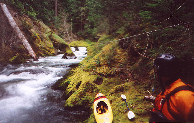
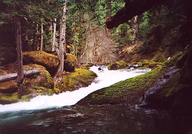
The next mile was a nightmare. Initially we were dropping 25-30 feet every hundred yards through incredibly complex and trashy boulder gardens. I suffered a couple pins in this section, but was able to work myself free from each. Also for about every 10 minutes spent in the boat, we would spend twice that time portaging over or around a logjam. I remember vague details of numerous tough portages, but one particular jam stands out in my memory. It was just above a large island. Take the exceedingly small left channel by slithering under a log while still in your boat. You will be able to bash/slide down most of the rapid and only have to get out of your boat once before reaching the end of the island. Josh opted for the larger right channel, and we waited for about 15 minutes while he was portaging. At this point, Nehi Creek has added about 1/3 to the flow, considerably cleaning up the rocky rapids. Below this island the gradient slowly tapers down to the 200 fpm range, and log portages become less frequent, and generally easier. Eventually you will find yourself floating through a long stretch of flatwater; perhaps a mile and a half. Its enough to make one wonder if the nightmare is over.
Below that rapid the creek was more reasonable, but continued to drop away at 200 to 300 fpm. Large logjams continued to be interspersed with trashy class IV and V rapids. One rapid was a double waterfall with each drop being about 6 feet. Both slammed onto shallow shelves; we portaged easily on the right. We portaged the logjams much less easily. At one point Josh solidly pinned himself on a boulder pile in the middle of a class IV+ drop; I actually ran into him and helped loosen his situation enough that he could slide off backwards. Somewhere in this stretch we stopped for a quick lunch of PowerBars and Gatorade. About 1/2 way through the run I was wondering when and if this hellish trip was ever going to end. I kept telling myself there had to be something to make this trip worthwhile (after all I knew several people had run the creek multiple times), but I was finding it harder and harder to imagine anything worth the hardships we had been putting ourselves through. Then somewhere around 4.5+ miles into the run, the gradient began to jump sky high and we finally found the "good stuff".
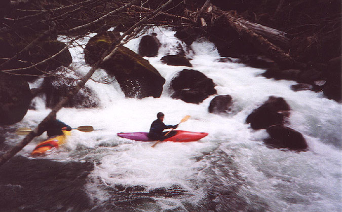
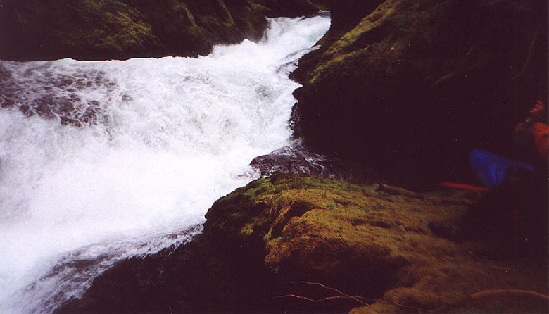
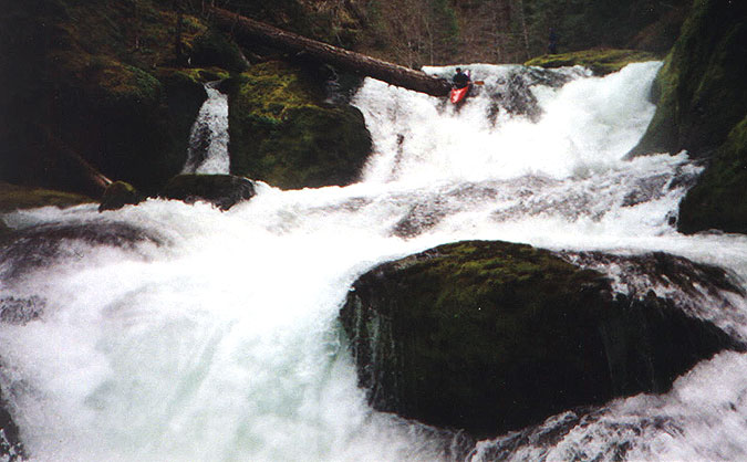
It started with a long class V boulder garden that dropped into the first gorge. After running the initial two pitches, I eddied out and began to scramble downstream. I climbed fairly high on the right wall and found the first class V that was basically 'unportageable'. Fortunately it was fairly clean, and also fun. After memorizing the route through this complex series of 6 drops, I headed back upstream to Josh and Gabe. They listened closely as I explained, "Gorged out class V, good recovery stretch below and just above what appeared to be a big waterfall. You must eddy out above the waterfall on the left to scout and portage. Take this initial drop trying to get to the center, move from center to right with speed and punch across a big pillow feeding into the narrow slot you see downstream, continue through the center slot that will then appear, stall out and ferry to far left, drop down a 6 foot flume, stay left and boof over a 10-12 foot falls with a meaty hole that should kick you out and left, punch the final 3 foot ledge on the far left and eddy out above the next rapid. We're on our own once we get on this one. Any questions?"
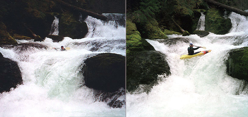
Gabe went first. His entrance over the initial drop didn't really allow him to start center, but he appeared to make it past the big pillow which fed into the 4 foot wide slot I didn't like. Beyond that we couldn't see him. Then Josh followed suit. However he didn't clear the pillow, it kicked his nose left and he was surfed into the midstream boulder pile, momentarily broached, and then was fed forward into the slot while flipping. He flushed through nicely and appeared to execute a roll just as he disappeared around the corner. I hoped for the best, and prepared for my own run. I didn't like how either had approached the initial drop. I ferried upstream, rounded a boulder, and went of the initial 3 foot ledge several feet left of Josh's or Gabe's line. This set me up further center, and allowed me more momentum heading into the pillow that had ruined Josh's line. I crashed through, took the next center slot, eddied, ferried to the left slot, and stayed left over the waterfall and through the final slot. Nearly text-book perfect! Fortunately both Josh and Gabe were waiting for me (Josh had in fact rolled immediately before sliding over the 4th pitch).
(Editors note: The drop mentioned above and pictured below was never named by the first descentionists but some paddlers now refer to it as 'Rhinosex'.)
Gabe followed my lead, and even seemed a bit farther right as he came down the first slide. Then somehow he flipped in the hole, and evidently was deposited along the right eddyline (I could see none of this). Eventually he was able to roll, paddled out of the eddy, took a sneak around the right side of the ledge-hole, and then sailed off the right falls.
Upon scrambling up the bank to Josh's truck we found it was 4pm. We had spent about 6 1/2 to 7 hours on that run. An amazingly long day. Considering how slowly we floated through the easy sections, I imagine it would have been easy to trim at least one hour off that time, but I doubt I would ever end up bombing down that run so fast as to reach under the 5 hour mark. I'm just way too cautious when it comes to woody rapids for that. We all did run nearly every rapid that was not log-choked (I did mistakenly portage much of the initial class V boulder garden, and I purposely portaged the shallow 12 foot double drop and Rhinosex). Most importantly of all though we ran them safely and in control. Or at least MOSTLY in control! ;-)
--Steve Stuckmeyer
The access point description and map, by Steve Stuckmeyer. Thanks Steve!
The alternate put-in involves driving along a unmarked FS road (marked in red, below) to the edge of a clear-cut that drops 500 feet down to creek level. The log boof that marked the end of the flat stretch I mention in the trip report is visible from the rim; this also marks the beginning of the final class V gorge... the section of Christy that is actually fun.
Getting to the creek involves three 150 foot rope lowers and lots of slipping and sliding, BUT it was nowhere near as bad as dealing with the many many logjams and trashy rapids that lie upstream.
I pulled up the satellite photos to zero in on the top of the clearcut that we dropped down through. I'm 100% certain that the marked waypoint is where we descended, and you can the see road we used is slightly darkened by the route I drew over it to calculate mileage. On the map below, the road is in red and the creek is in blue.
After reaching the more level area close to river level it's advised to work to the far downstream edge of the clearcut before descending the final hundred feet to the creek. That saves you an immediate portage.