Oregon Kayaking's mission statement reads: "This non-profit, independent site is meant to be a source of information about PADDLING and PRESERVING our precious rivers and creeks." The primary way I do this is by demonstrating an indisputable record of use, which is important when it comes time for hydroelectric licensing and re-licensing. I try not to be too political on this site, but we need to remain vigilant because the need for power will only increase over time. I strongly encourage all paddlers to join American Whitewater; this superb non-profit organization works hard to protect Canyon Creek and countless other rivers and creeks across the country.
| CONTROL NUMBER | BUSINESS/PERSON NAME | PRIORITY DATE | PURPOSE | SOURCE TRS QUAD |
| S2-28278 | WALTER MUSA JR. | 09/12/1991 | POWER | CANYON CREEK - T05 N/R04 E-05 |
The Canyon Creek down river race is still alive and well today, and Canyon Creek flows healthy and strong from October through May, except in very dry years. Paddlers from around the world have paddled and continue to enjoy this classic, endangered run.
When arriving at the put-in for Canyon Creek, paddlers often check the flows on the downstream creek-left bridge piling, which is known as 'The Unit'. Generally a good first-time flow is level with the base of the unit. The creek becomes class V above about three inches the unit, and has been run as high as 30 inches above the unit ( see chart at the end of this report for unit measurements and flow correlations ).
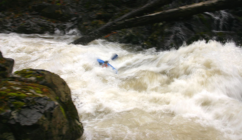
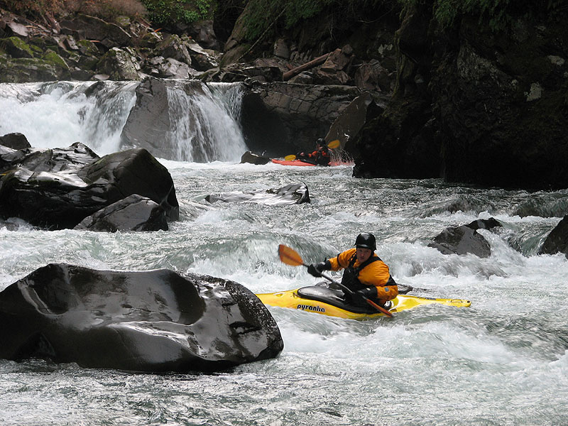
If you put in at the bridge, the first major rapid is Swizzle Sticks ( Aka Entrance ), named for the logs that used to extend down from the wall into this rapid. Scout right and get ready for your first big hole of the day..
Mike Novak runs Swizzle Sticks, or Entrance drop.
Kris Wilson blasts through Swizzle Sticks during an outlandishly high floodstage run ( at 30 inches above the unit ).
Below Swizzle Sticks the gradient cools off briefly, allowing paddlers to enjoy the scenery. Just downstream from here is a bridge high overhead, where bungee-jumpers are often seen on the weekends.
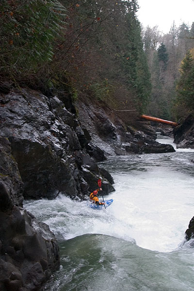
The first serious drop on Canyon Creek is the appropriately named 'Terminator', which appears just downstream of the high bridge. You can scout Terminator from just upstream of the drop on either side and set safety on the right. Terminator has a big, powerful hole that has mauled lots of paddlers. Drive left and boof hard to avoid the hole, which gets worse the farther right you go..
If someone swims Terminator, there isn't a lot of recovery time before the next drop, so be sure to fish out any swimmers quickly! Below Terminator the walls close in and there is a fun slide that is somewhat difficult to scout though you can eddy out at the lip and peek over the edge.
Below this drop things calm down again, but things get going again with Thrasher Prelude and Thrasher. Scout these drops on the left, and pay particular attention to the hole which gives Thrasher it's name..
Shaun Riedinger runs Thrasher Prelude.
Pete Giordano runs Thrasher.
Below Thrasher the walls peel back a bit and the creek tumbles through a boulder garden with a big hole at the bottom, scout and/or portage on the left side. Below this boulder garden the creek mellows as you approach the 'Drop Zone', where the creek roars over four large drops.
The first falls in the drop zone is known as 'Big Falls', which has a convenient scouting platform on the right side ( this drop is also sometimes referred to as 'Big Kahuna' by the most recent generation of paddlers ). This 17-foot drop is about as clean as you could ask for at most flows, but it gets burly at high water.
You can run this drop any way you like, but most take the nice boof on the right side. Be sure to scout this drop carefully, because there are undercut walls on either side, especially on the downstream creek-right side. Paddlers who chose to portage Big Falls will have to do a throw-and-go into the pool below as the creek is totally gorged-out at this point.
Here's a couple of photos of Big Falls/Big Kahuna from various angles..
Chuck Taylor drops into Big Falls.
Si Wiles ( visiting from the UK ) fires up the Big Falls.
Mike Novak runs Big Falls, viewed from the side. The undercut walls are clearly visible here.
Below Big Falls are some smaller rapids leading up to the grand finale, Champaign and The Hammering Spot. Scout these two drops on the left. Champaign is a benign ten foot falls that drops into a moving pool that moves quickly towards The Hammering Spot just downstream. Paddlers generally boof Champaign in the middle, then drive hard right to avoid the hole in the Hammering Spot..
Nate Garr airs it out at Champaign. The Hammering Spot is clearly visible on the bottom creek-left side.
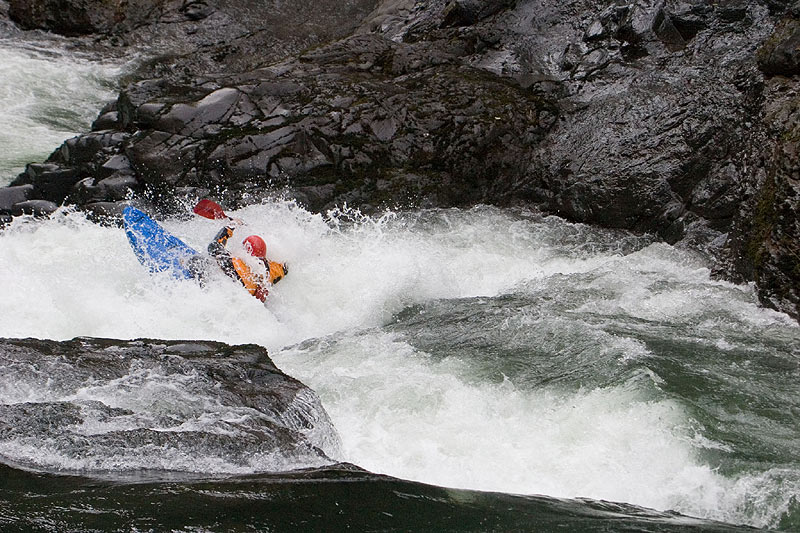
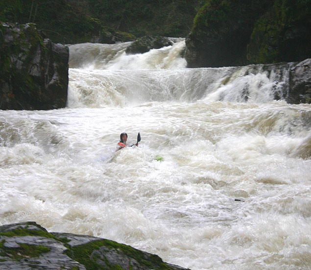
Kris Wilson below the Hammering spot during a floodstage run down Canyon Creek ( 30 inches above the unit ).
Below the Hammering Spot is another big horizon line marking Tobys, the first recommended portage. Toby Scarpella drowned running this ledge on March 7th, 2000 and there have been several other close calls. There are invisible rocks in the landing that pose a severe entrapment risk, so I highly recommend portaging this drop on creek left.
Bob Lee and friends below Tobys. The portage ledge is visible on creek-left.
Just below Tobys the creek comes crashing to a stop in the slackwater of Merwin Reservoir. From here it is about a mile or so of flatwater slogging to reach the take out.
While there is no direct internet gauge for Canyon Creek, the USGS internet gauge EF Lewis at Heisson correlates nicely with the foot gauge at the put-in bridge. Canyon Creek runs October through May, except during drought years. The fact that this creek runs for eight months out of the year combined with its proximity to Portland makes it one of the most-paddled creeks in the Northwest.
The general rule for flows is anything below the unit is low, and anything above the unit is high. If the water is level with the unit the creek is at a medium level, which roughly corresponds with 1,200 on the East Fork Lewis gauge.
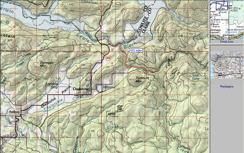
A map with a red dotted line showing the normally run section of Canyon Creek.
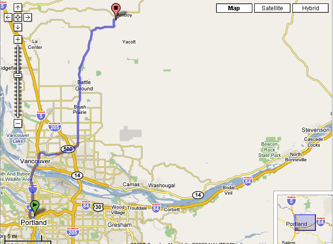
The Google map from Portland to Amboy, the nearest town. The drive time from downtown Portland to Amboy is about 55 minutes.
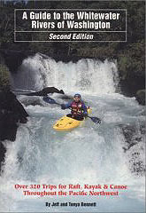
For directions to the put-in and take-out, as well as other info, pick up the second edition of the bible, Jeff Bennetts 'A guide to the Whitewater Rivers of Washington', a book no serious Northwest paddler should be without. You can pick this book up at your local paddling shop, or on amazon.com.
This rapid changed in the flood of 2006, when the logs were pushed downstream.
photo by Brian Vogt
The logs that gave this rapid its name ( visible in the photo ) were washed away in the 2006 flood.
photo by Jim Pytel
Mike Novak fires up Terminator.
photo by Brian Vogt
Shaun Riedinger squares up on Terminator
photo by Brian Vogt
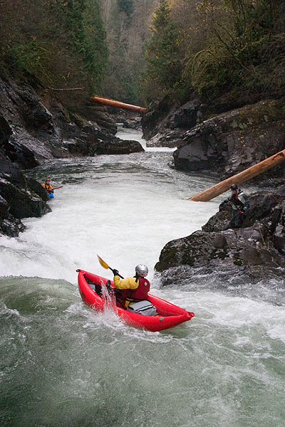
photo by Brian Vogt
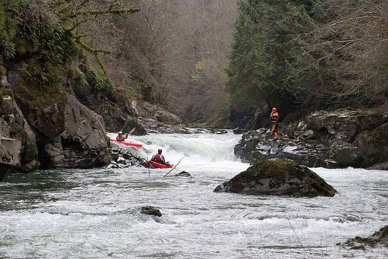
photo by Nate Garr
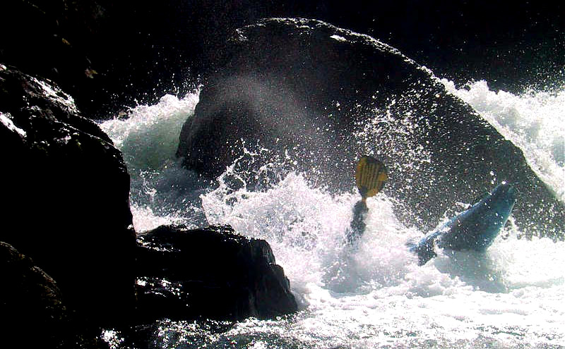
photo by Mike Long
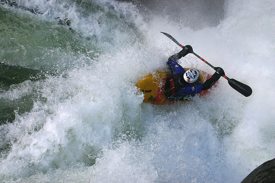
photo by Mark Rainsley
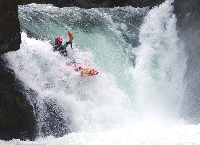
photo by Brian Vogt
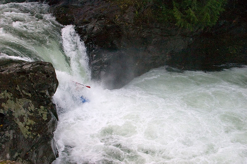
photo by Mike Long
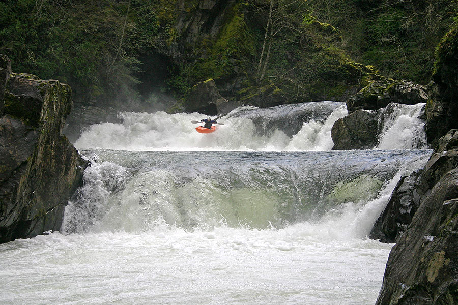
photo by Jim Pytel
Chuck Taylor and Tony Crawford run Champaign and The Hammering Spot in the 'Topo Duo' class
at a recent Canyon Creek downriver race.
photos by Brian Massey
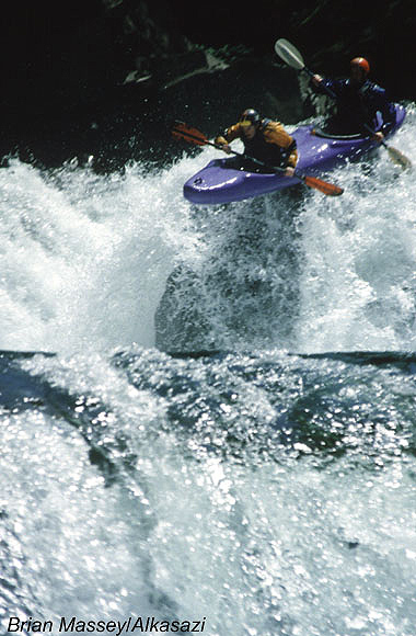
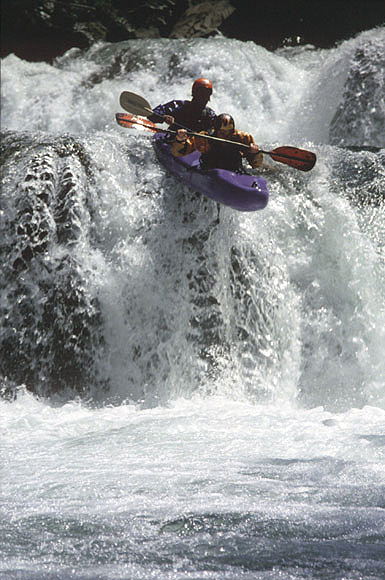
photo by Brad Bassi

EAST FORK LEWIS AT HEISSON
DESCRIPTION
INCHES ABOVE OR BELOW THE UNIT
CLASS
500 CFS
MINIMUM RUNNABLE FLOW
MINUS 12 INCHES
IV
700 CFS
LOW
MINUS 6 INCHES
IV+
1200 CFS
MEDIUM
0 INCHES
V-
1600 CFS
MEDIUM-HIGH
PLUS 3 INCHES
V
2000 CFS
HIGH
PLUS 6 INCHES
V
FLOODSTAGE
INSANELY HIGH
UP TO PLUS 30 INCHES
V+
Be sure to hug the left bank on the paddle out across the reservior.